
Samson destroying the Philistine House

Samson destroying the Philistine House

Philistine House Collapsing

Jim playing Samson

Grandpa Bill Playing Samson
Following the performance of Miracle of Christmas which was spectacular we drove Hagarstown, Maryland where we stayed in a Comfort Inn Suite. After a much needed nights rest we spent the 19th of November driving around getting to know the lay of the land. We first drove to find the race staging area at the Boonsboro High School. This is where the runners assembled the morning of the race. Boonsboro was founded in 1792 by George and William Boone, cousins of frontiersman Daniel Boone. This town has been the starting point of the John F. Kennedy Memorial 50-mile since it started in 1963.Then we drove to downtown Boonsboro to see the starting location.We next took off to find the various places that I could see him and provide him with water and any other thing he might need. There were at least 14 fully stocked Aid Stations. Many of these were not accessible by car but we visited all that were accessible by car. This occupied the entire day and we programmed the location of each into my GPS. The night of the 20th we attended a spaghetti dinner for the participants. At this dinner a great amount of time was spent and properly so in recognition of several runners. Recognizing both male and female runners for the number of times they have run in this Ultra Marathon, the number of times they finished, winning times and several other categories. The key note speaker was the female winner of the 2014 race Sara Bard. The morning of the 21st we went to the Boonsboro Educational Complex where the runners received their numbers and chip for the electronic timers. Last minute instructions were given by the race Director Mike Spinnler. There was a 5:00 AM start time for elite runners the category Jim was in. There was a 7:00 AM start time for the bulk of the runners. The runners proceeded to walk about a quarter of a mile to the start line in downtown Boonsboro to the start line.
Race Director Mike Spinnler

Participants getting their food.

My Meal

2014 female winner Sara Bard

Jim is all suited up and ready to go. Just in case you might be wondering what Jim is wearing. Yes, that is a large trash bag that he and many of the runners tear a hole in the bottom and for the head and arms for protection from the cold and rain. It also is easy to tear off where that is needed.

Last minute instruction before the start. Clock on my camera has not been adjusted for the time change.

And they are off. One interesting fact is that personal listening devices are strictly prohibited for this event. The Appalachian Trail which they will run on in the morning darkness has dangerous footing and is a single trail and if you cannot hear the person behind you asking for the trail you are creating a dangerous situation. When a runner overtakes another and wants to pass him/her they "ask for the trail" and the runner moves over to let the other past. Any runner caught using a personal listening device will be disqualified. Race officials will be stationed along the route to monitor this situation. Cell phones are permitted but are for emergency situations only.
The Appalachian Trail was completed in 1937, This trail is 2,157 miles long and stretches from Mountain Karahdin, Maine to Springer Mountain Georgia. 13 miles of the JFK 50 mile race traverses this famous footpath.
The Appalachian Trail was completed in 1937, This trail is 2,157 miles long and stretches from Mountain Karahdin, Maine to Springer Mountain Georgia. 13 miles of the JFK 50 mile race traverses this famous footpath.
A few words about the route of the race is needed to fully appreciate what a difficult race this is. The first 5 1/2 miles starts on road surface and joins the Appalachian Trail at the 2 1/2 mile point which gains 1,172 feet in elevation. The course from 2 1/2 mile to 15 1/2 miles is on the Appalachian Trail except for two miles of paved road between 3 1/2 and 5 1/2 miles. This section of the Appalachian Trail is very rocky as it rolls across the mountain ridge, At approximately 14 1/2 miles the course drops over 1,000 feet in a series of steep "switchbacks" that then crosses under route 340 and connects with the C&O Canal Tow Path. The Canal section is 26.3 miles from 15 1/2 - 41.8 miles is almost totally flat unpaved dirt/gravel surface that is free of all automotive vehicle traffic. The route leaves the C & O Canal Tow Path at Dam # 4 and proceeds to follow gently rolling paved country roads the last 8.4 miles to the finish. The Boonsboro start is at an elevation of 570 feet and the finish at Williamsport is at 452 feet above sea level. There are 26 significant points of interest that the race passes thru but I will mention only a few.
A race this long and lasting for 14 hours you would expect some surprises not only for the runners but support crew members like myself as well. Like I said Jim and I visited all the Aid Stations that were accessible by car. To my surprise on the day of the race many of these Aid Stations were blocked off so spectators and even support/crew people could not gain access to them. This did not present a major problem for Jim because the Aid Stations were all well stocked and Jim being an experienced marathon runner always carried some emergency items that he might need. But it presented a major problem for me. First we had programed into my GPS how to get from each of these Aid Stations to the next in sequential order. First of all I have a new GPS which I am only barley familiar with how to operate it. To my surprise I found out that this GPS will only store 5 locations and we thought we had programed in many more than that. Now I am flying blind trying to find my way around and find ill defined locations without specific addresses such as (Snyder's Landing or Taylor's Landing) and in some instances finding out that many of the local people are not at all pleased with the enormous amount of traffic this event brings into their back and front yards. Roads from one of these locations to the next are extremely narrow and in many places two cars cannot meet. One has to stop and back up to a wider spot in the road. My main concern was that these runners depend on their support/crew to meet them and provide aid as needed. For example some will change type of shoes they are wearing. As the day gets warmer some may remove one layer of clothing, change hats/caps and a number of other reason. I was worried that Jim might need something and I would not be there to help him and thus potentially cost him a finish of the race. As it turned out at the first place I was not able to get to because it was closed off Jim was worried that something had happened to me although he could tell there were not any spectators there only people working the Aid Station but it was not until I was able to meet him later that I could tell him I could not get to certain Aid Stations. So throughout the remainder of the race if I was not there he knew it was because it was blocked off to vehicle traffic. In at least two instances the Park Rangers who blocked the roads told me they could only permit people who lived in the area to go past them and to those he gave a pass to show they were authorized to enter the area. I will admit I tried my best to see if there were any back roads that were not blocked but no they were all blocked.

Some local people put their own sign at the entrance to the road leading to the race. This was at the normal entrance to the Weverton Aid Station You can see what it says.

The First Aid Station At The Gathland State Park. The large structure in the background is the War Correspondents Memorial

War Correspondents Memorial

Stone work of old house.

In the gap in the fence on the right (in the shade) is where the runners will come out of Appalachian Trail to the Aid Station. The morning of the race it was pitch dark when I arrived at this Aid Station. When the people came to set up the Aid Station they did not have any lights at all. I had my big LED flashlight so I held it so the people could see how to mix Gator Aid and be able to do some other things. I had to laugh to myself. They were going to mix the Gater Air in the darkness without being able to read the directions or see how much they ere mixing. It was interesting that this was one of the Aid Stations that was not open to support/crew personnel and spectators. Some race officials were trying to keep people from parking and coming into the area. I told one such person that this was a state park and that I had ever right to be there to visit it. At one point the small parking lot filled and that effectively stopped many people from coming in although I would estimate there were around 100 support/crew, parents and such that were there to cheer their runner on. When Jim came out of the woods into the park area it was very dark and I had him come across the street so I could give him what he needed. At this stop as at all of them they had porta pots for every ones use. Jim was in good shape and headed back into the woods and onto the Appalachian Trail.
This entire area is rich in Civil War history and many battles were fought on these grounds. Gathland State Park is one such area as fierce fighting occurred here in the Battle of South Mountain in 1862. On September 14, 1862, about 10,000 Confederate soldiers under Gen. Robert E. Lea defended three mountain passes--Turners Gap ( where today's Route 40A crosses ), Fox Gap ( where today's Reno Road crosses), and Cramptons Gap ( at today's Gathland State Park) -- against the advance units of Gen George B. McClellan's 80,000 man army. Lee had split his 40,000 man army to capture Union troops in Harper's Ferry and defended South Mountain here to buy time for his divided army to join him near Sharpsburg where the Battle of Antietam was fought September 17, 1862. The Antietam Battle Field is a major park with a visitors center and manned by Park Rangers.The Cramptons Gap area was bought by reporter George Alfred Townsend (pen name: Gath) in 1884. In 1896 Townsend organized the construction of the War Correspondents Arch here to commemorate correspondents and artists of the Civil War.
The following photograph provides a good illustration of much of the C & O Canal as we see it today. The Potomac River is on the right of this photograph. Next to the river you can see the tow path where the mules walked as they pulled barges/boats on the canal. To the left of the tow path you see the depression which was the canal. To the left of the canal you see a paved road which parrells much of the canal. In the distance you can see what remains of one of the locks on the canal. Also at this point the railroad crosses over the canal. The B & O Railroad was started in Baltimore, Maryland July 4, 1828. It reached this area in 1834 and went all the way to Cumberland, Maryland in 1842. Today the CSX Rail Transportation System use these tracks.
The next Aid Station was the Weverton which was one block from entrance. Spectators had to drive down highway 67 a few miles, park along the shoulder of the road and walk to the access road and take a shuttle bus to the aid station. Weverton was a tiny village which was founded in 1830 by Casper Wever. Water from the Potomac powered mills here for 50 years before floods and finances forced them to close.This is the point where the runners come off the Appalachian Trail. This is the point on the trail where there are several steep and rocky switchbacks and the trail drops over 1000 feet.

The Chesapeake & Ohio construction was started in Washington, DC on July 4,1828. There was a race to find the best form of transportation to the west. Was to rail or water? The C & O reached this area by 1834, but construction problems prevented it from reaching Cumberland, Maryland until 1850. The C & O ceased operations in 1924 and today is preserved as the 185 mile-long C & O Canal National Historical Park. 26 miles of the JFK-50 Mile Marathon itself - follows the park's tow path where miles once pulled canal boats.
This entire area is rich in Civil War history and many battles were fought on these grounds. Gathland State Park is one such area as fierce fighting occurred here in the Battle of South Mountain in 1862. On September 14, 1862, about 10,000 Confederate soldiers under Gen. Robert E. Lea defended three mountain passes--Turners Gap ( where today's Route 40A crosses ), Fox Gap ( where today's Reno Road crosses), and Cramptons Gap ( at today's Gathland State Park) -- against the advance units of Gen George B. McClellan's 80,000 man army. Lee had split his 40,000 man army to capture Union troops in Harper's Ferry and defended South Mountain here to buy time for his divided army to join him near Sharpsburg where the Battle of Antietam was fought September 17, 1862. The Antietam Battle Field is a major park with a visitors center and manned by Park Rangers.The Cramptons Gap area was bought by reporter George Alfred Townsend (pen name: Gath) in 1884. In 1896 Townsend organized the construction of the War Correspondents Arch here to commemorate correspondents and artists of the Civil War.
The following photograph provides a good illustration of much of the C & O Canal as we see it today. The Potomac River is on the right of this photograph. Next to the river you can see the tow path where the mules walked as they pulled barges/boats on the canal. To the left of the tow path you see the depression which was the canal. To the left of the canal you see a paved road which parrells much of the canal. In the distance you can see what remains of one of the locks on the canal. Also at this point the railroad crosses over the canal. The B & O Railroad was started in Baltimore, Maryland July 4, 1828. It reached this area in 1834 and went all the way to Cumberland, Maryland in 1842. Today the CSX Rail Transportation System use these tracks.
The next Aid Station was the Weverton which was one block from entrance. Spectators had to drive down highway 67 a few miles, park along the shoulder of the road and walk to the access road and take a shuttle bus to the aid station. Weverton was a tiny village which was founded in 1830 by Casper Wever. Water from the Potomac powered mills here for 50 years before floods and finances forced them to close.This is the point where the runners come off the Appalachian Trail. This is the point on the trail where there are several steep and rocky switchbacks and the trail drops over 1000 feet.

This area along the river is beautiful The river here is relative smooth but in many area is very rough with large boulders and many swift rapids. George Washington envisioned the Potomac River as the gateway to the west.
Photograph at the Gathland Gap Aid Station depicting Union and Confederate soldiers facing off in a fierce battle.


Taylor's Landing on C & O Canal. The community here was first called Mercersburg, for the first president of the C & O Canal Company.


He Sees Me. Notice the runners and crowd. In some areas the support/crew members as well as spectators would line the trail for at least a quarter mile on either side of the aid station. Most areas the space for spectators was very narrow with the river on the right and the canal depression on the left. In a couple of instances I saw spectators interfering with the runners.In most areas we had to park along the side of the road or in some pasture which had been turned into a parking lot meaning a nice long walk.


There are two points along the race that I was not able to get to but which I want to comment on because their historical significance. Harper's Ferry was founded in 1733 as a ferry crossing the Potomac River. Harper's Ferry became famous for its privately owned and federally funded gun factories and arsenals from the 1790s through the 1850s that attracted John Brown's ill-fated raid in 1859 to gather arms for a slave rebellion. During the Civil War, Harper's Ferry's armories and arsenals were destroyed as the town changed hands 8 times between Union and Confederate forces. Today's Harper's Ferry National Park preserves much of the historic town and the surrounding mountains - Bolivar Heights (WVA), Maryland Heights (MD), Loudoun Heights (WVA and VA), and Short Hill (VA). Harper's Ferry Road across from the canal on the night of September 14, 1862, about 1,500 Union cavalryman made a daring middle-of-the-night escape from a Confederate trap by riding their horses across a bridge and up this road to Sharpsburg. The next day, the remaining 11,000 Union soldiers surrendered. This was the largest U.S.troop surrender until WWII. On September 16, most of the Confederate troops marched up this road to rejoin General Robert E. Lee outside Sharpsburg for what would be the bloodiest one-day battle in American history.


Jim nears Aid Station in Downsville (Mile 46.0) which will be on his left when he turns a corner on his left just ahead. He did not want anything. He is headed full steam ahead for the finish a little less than 4 miles ahead .

Jim turns corner and headed for the finish line just ahead.


Congratulation Jim.
The finish line is in Williamsport, Maryland which was founded by the Williams brothers in 1786 who proposed to George Washington that this area would make a good location for our national capital before Georgetown, Maryland was selected in 1790. Williamsport was especially prosperous during the C & O Canal's heyday from 1840 to the 1880s. Since 1980, Springfield Middle School here has been the finish line of the John F. Kennedy Memorial 50-mile Ultra Marathon.
At the conclusion of the race the runners go into the school for some rest and refreshments including chicken noodle soup. Following this we went back to Hagarstown, Maryland to our motel and cleaned up. We both were famished for food and found a Chinese buffet where we ate. I know it is not true but I felt like I had walked as much as Jim.
One final thought before I move on and that is we all have heard about runners taking short cut in marathons or entering the race a short distance before the finish. In this race each runner has a electronic device they fasten to their shoe laces which shows they started the race. At each Aid Station along the route there are officials which record the number of each runner as they pass and the the number is electronically recorded at the finish. They keep track of the runners who start the race but do not finish. So I think we can safely say any cheating would be caught.
Another factor is that they have cut off time for each runner to pass eight Aid Stations including the finish. Should a runner not pass a particular Aid Station in the time allowed that runner is disqualified. For example all runners whether they started at the 5 AM or 7 AM must finish by 7 PM or they are considered as not finishing. Also, the time on the race was 2 hours shorter for the 7 AM starters than for the 5 AM starters. Since Jim was in the 5 AM starting group I will show only the cut off times for his race from the start.
9.3 Miles (Gathland Gap) 3 hours and 30 minutes (8:30 AM)
15.5 Miles (Weverton Aid Station) 5 hours and 30 minutes (10:30 AM)
27.1 Miles (Antietam Aid Station) 8 hours and 00 minutes (1 PM)
34.4 Miles (Snyder's Landing) 9 hours and 45 minutes (2:45 PM)
38.4 Miles (Taylor's Landing) 11 hours and 00 Minutes (4:00 PM)
41.8 Miles (Dam #4) 12 Hours and 00 Minutes (5:00 PM)
46.0 Miles (Downsville) 13 Hours and 00 Minutes (6:00 PM)
50.2 Miles (Finish Line) 14 Hours and 00 Minutes (7:00 PM)
Jim had wanted his pace to be such that would have him finish the race in 12 hours and 36 minutes. His time was 11 hours 47 minutes,18 seconds so he was able to maintain a pace faster than planned which is good.
On the morning of November 22, 2015 we ate a hot continental breakfast at the motel then headed for the Gettysburg National Military Park in Gettysburg, Pennsylvania. When we arrived the first place we visited was the Visitor Center book store for some shopping and then bought our tickets to the Gettysburg Cyclorama.This is a massive painting by Paul Philippoteaux's depicting Pickett's Charge, the final attack at Gettysburg.This painting was first displayed in 1884 in Chicago. There is some disagreement as to which version was the first. There were four of them.The one shown in Chicago or the one shown in Boston. Cycloramas are very large panoramic paintings shown in the round. The word panorama simply means to see all. The term cyclorama actually refers to the environment in which the panorama is exhibited. Cycloramas first appeared in Europe after the 1750s and over the years have changed in many way from unrolling the massive paintings in front of the audience to having the massive painting mounted in circle with audience seated or standing in the middle. There were hundreds of cycloramas covering a variety of subject but due to waning interests none are known to have survived. There were four cyclorama painting of this Gettysburg battle painted. One is known to have been destroyed. One bought and located in North Carolina. One's presence is unknown and the one here at Gettysburg. The first version was shown in Boston in 1884. The impact is that you feel like you are right in the middle of the battle. For example you may see or hear a cannon shot behind you and you turn quickly and see the results of cannon ball hit its target in front of you. This painting has undergone several changes and reworks due to damage and finding of new information about the battle that it depicts. Different version have been shown over time in various cities. One thing I found interesting was that as the painting was shown in various cities they would publish a key assigning numbers to different sections of the painting to help you know what you were looking at. It appears that some times items of local interest may have been added to the key. The cyclorama here at Gettysburg is a second version of the famous painting depicting the battle of Pickett's charge July 3, 1863. The painting is 42 feet high and 377 feet long .
I bought a book entitled "The Gettysburg Cyclorama: The Turning Point of the Civil War on Canvas" which is the first comprehensive study of this art masterpiece and historic artifact. It tells the history of cycloramas and details of how there are produced and the various environments in which they have been shown. This book breaks the painting down in sections numbered zero thru 9 and give a detailed explanation of what you are seeing in each section. Fantastic in detail.
Following the cyclorama we started the automobile tour of the park. This takes you through the old town of Gettysburg and through the entire park and past every single point of interest whether it is a major monument or a single small marker. You can stop at each, get out of the car, walk to the item of interest and read what is important about each item. The major monuments are spectacular and many are very large. There is a monument for every state that fought in the Civil War. Many of them give the names of the soldiers and details about the number killed, missing and injured. It is interesting and note worthy that the town of Gettysburg had a number of roads that led to it and for that reason it was selected by the generals as the site for a major battle due to the ease of moving supplies and troops. This quiet little town was caught in the middle of this great battle. It is reported that every home and building was turned into a location when the wounded and dying were treated and cared for regardless of which side they were fighting for. It was also reported that long after the battle was over this little town was left devastated with thousands of dead bodies lying all over the surrounding field and woods and the task of trying to bury them. Much later many were dug up for identification and movement to proper burial grounds in the north or south.

Jim seated with the Abraham Lincoln statue outside the visitors center.

Observation Tower

Jim getting a lay of the battlefield from the observation tower
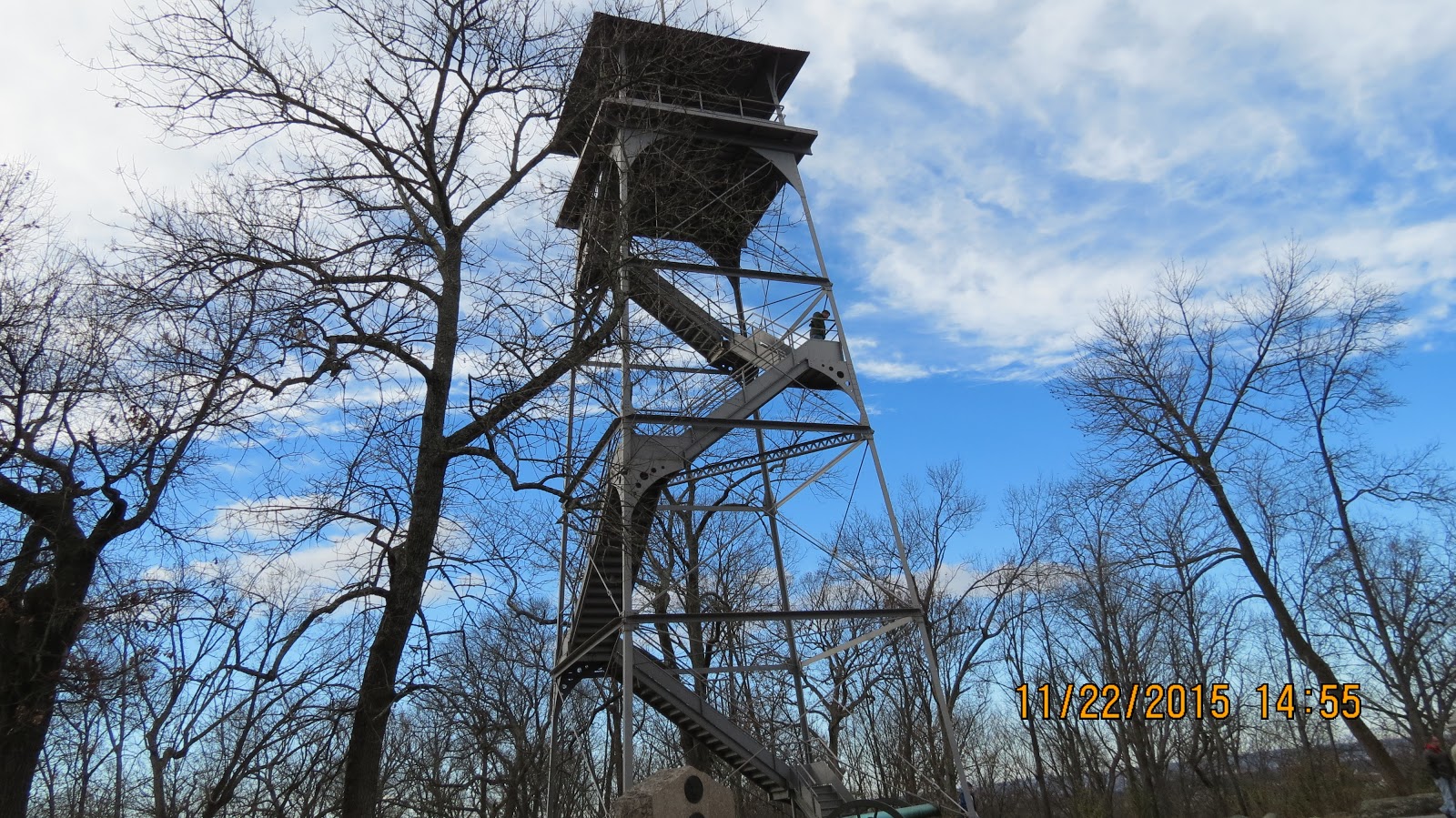
Another observation tower.

Jim waves to me from the observation tower. He just has to climb a tower if one is there.

Brevet Major General George Sears Greene


Photograph of Major Brig. General George Sears Green

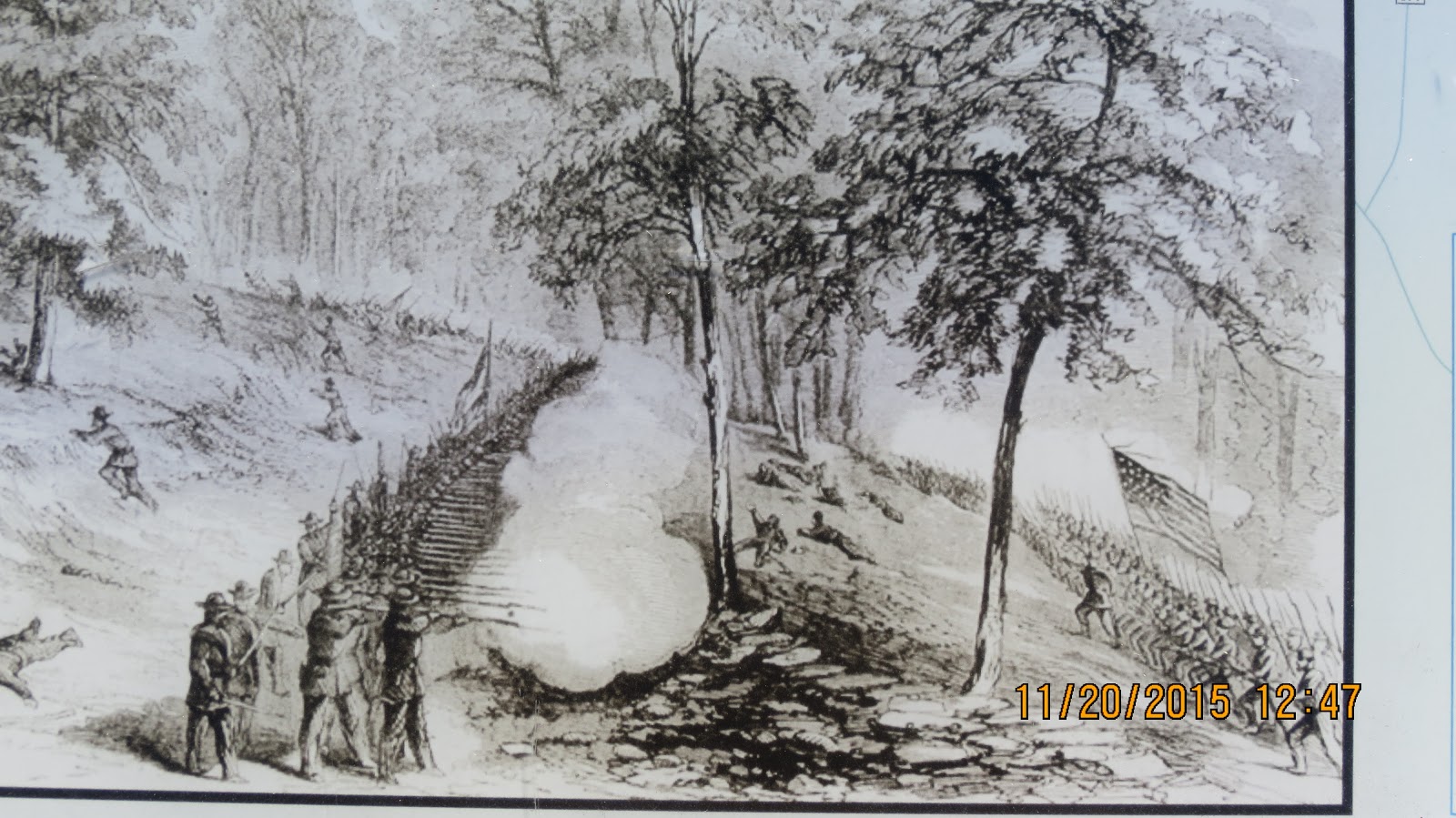
Defense of Culp's Hill

Enlargement of Defense of Culp's Hill

Continuation of Enlargement of Defense of Culp's Hill
We continued following the automobile tour route with Jim getting out and viewing items of interest as we went along. It was very windy and at some of the locations such as higher sites it felt a lot colder than it actually was. At the conclusion of the tour we left Gettysburg and headed for Ohio.
This was a most enjoyable trip getting to see a lot of beautiful country, the wonderful stage production of the "Miracle of Christmas", getting to see Jim run the JFK 50 mile Ultra Marathon and seeing the Gettysburg National Military Park again.
Remember as I always say God loves you and so do I.
Grandpa Bill