Boston is a beautiful city that is so chock full of historical places, facts and events that you have to read the entire history of America to begin to touch on it all. Also it needs to be noted that the Boston of today is vastly different in size and shape to what it was in it's earlier history because very large areas of marsh / wet lands have been filled and built upon or converted into parks. There have been a number of phrases over the years that have been used to capture this thought. A couple that we saw and heard were " The Cradle of Liberty " and " the Birthplace of American Independence ". The Freedom Trail is roughly 2.5 miles long and is really divided into 2 sections. One section in Boston proper and the other in Charlestown. The Boston section has the most historic places. You might wonder how in the world can you follow the Freedom Trail. Well it is actually easy. It is marked on the sidewalk either with a row of red bricks or a painted red line. Just follow the red line. If you ever plan to visit Boston and walk the Freedom Trail which I highly recommend you really should do some research on the trail to see what you can actually see and how much time you want to spend on the trail. One reason for this research is that in many places just a block to the right or left of the Trail but not on the Trail you will find very interesting and historic locations. Unfortunately I did not do this so we missed some interesting places. For us it took about a day an a half. I was constantly amazed the way a lot of people sped along the trail. They did not take time to read any of the informational sign about the places or events that occurred at that point. I can only imagine that they had a very limited amount of time so they hurried along so that at least they could say they saw the Freedom Trail. We walked the trail but there are bus tours, walking guided tours ( you really have to watch out for these because they are large groups and they think they own the trail ). I mean by this that you may be standing in front of a building or monument and this group comes by and the guide takes a position right in front of the monument and asks the group to gather around which they do and you can get trampled easily. They also have " Duck " vehicle tours. These are old World War II vehicles that can travel on land or water. They have converted these into tour bus like vehicles and they are numerous. Of course there is an advantage of staying close to one of these guided tours because you can hear for free what the tour group had to pay to hear. The only problem is they really don't spend much time at each location and for me they were moving just to fast. I want to spent more time at each location. Finally, before we get into a detailed description of our exploring the Freedom Trail if you come to Boston don't plan to drive the Freedom Trail because you can't. Many of the streets you walk on or by are very narrow, have no parking spaces and many will be one way going the opposite way you need to be going. Park the car and put on your walking shoes. OK lets get started and I will try to describe what we saw and some of the information about what we saw.
The Freedom Trail begins at the Boston Commons which is said to be America's oldest public park. It is located in the center of the city and encompasses 44 acres of land that has never been built upon except for monuments and that sort of things. In 1622 a group of colonists came to this area after their first location just south of here proved to not have a adequate water. One of these settlers was William Blackstone and he lived on this land ( what is now known as Boston Commons ) as a hermit and he used this land for grazing pasture for his cattle. At that time this area was called Shawmut ( living waters ) by the Indians. Later it was renamed Boston after a town in England from which these settlers had come.. Blackstone's pasture land became known as the " common lands " or " commons " for short. Over time the Commons has been used for several things. Training grounds for militia, a British Camp when the British occupied Boston. The area known as Beacon Hill became a fashionable residential area and the cattle were relocated elsewhere. The common was also used for the location of the town gallows for execution of pirates, witches, heretics as well as Quakers. Throughout the years it has been used for a place to hold celebrations, demonstration, rallies and speeches. Any one who wishes can find a spot and say a few words or talk all day if he or she can do it. And it can be almost guaranteed that an audience will form to listen. I observed. two such speakers. One was a preacher who was boldly standing in front of a small statue and preaching from the Bible. Another individual was railing about the war in Afghanistan. Interesting the poor preacher was pushed out of his location by one of the tour groups I mentioned earlier. He just moved out of the way and did not miss a beat. There are many paved side walks that cris cross this very large park which is mostly grassy area with large trees through out the area. You will see all sorts of activities taking place, walking, jogging, writing, painting, photography, reading, playing all sorts of sports and of course a little romance. Ain't love grand? But, I digress. Lets look at some photographs of the Boston Commons.
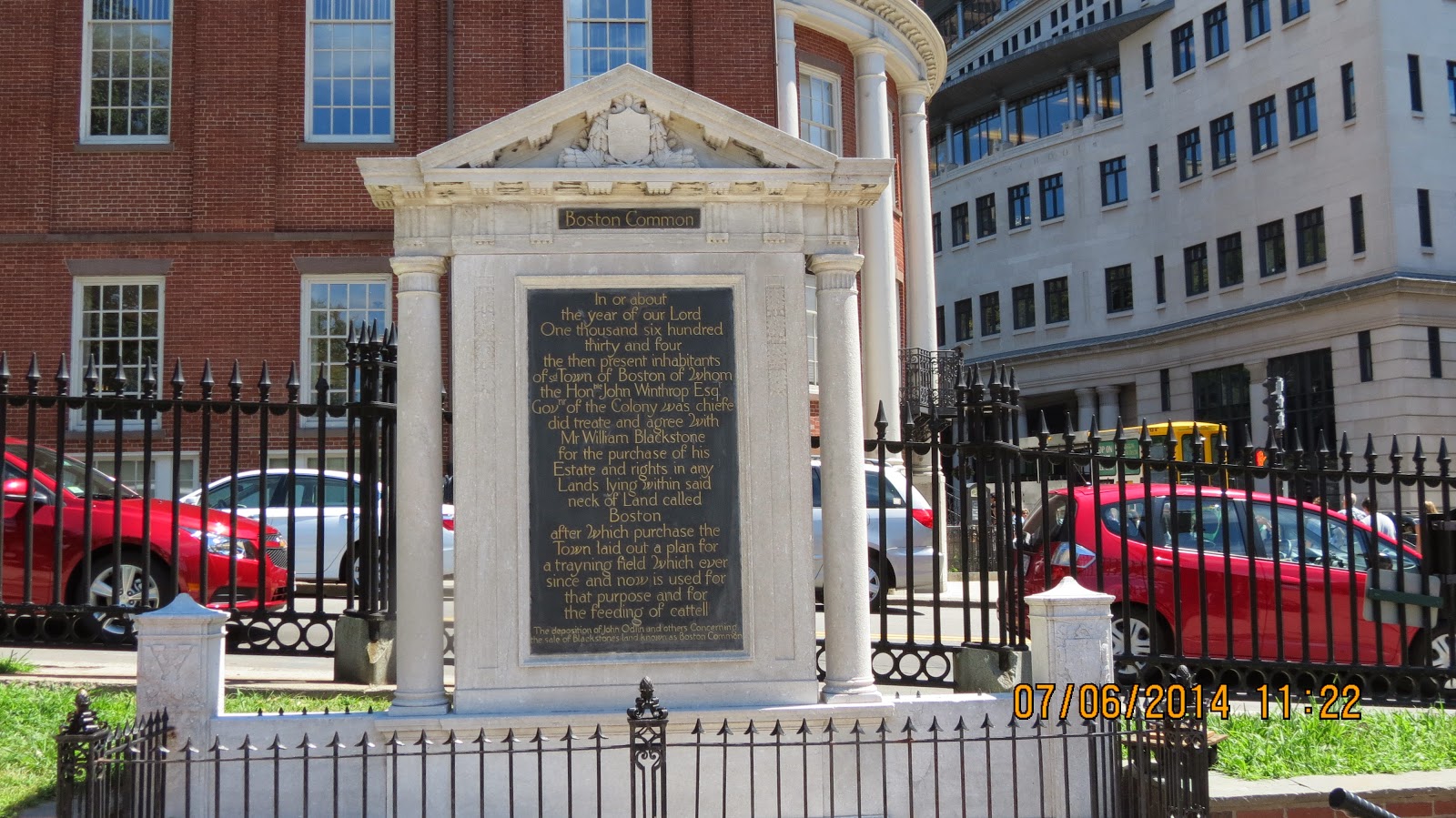
Plaque Describing The Purchase Of This Land From William Blackstone

Enlargement Of Plaque Describing The Purchase Of This Land From William Blackstone

Milmore. It Is 126 Feet Tall And Stands On Flagstaff Hill.

Top Piece Of Above Monument Is A Female Figure That Is 11 Feet Tall. She Is Wearing A Crown With 13 Stars That Represent America ( 13 Original Colonies ). Here Right Hand Holds A Sword And Laurel Wreath And In Her Left She Holds An American Flag. Eagles Sit On Each Side Of The Base She Stands On.

Lower Section Of Above Monument. As I Understand It These 8 Foot Tall Granite Carved Figures Represent The Northern, Southern, Eastern And Western Sections Of The Reunited Nation.

Dedication Plaque On Above Monument With The Sculptor's Name - Martin Milmore.

Lower Section Of Monument.There Is A Lot Of Interesting History About This Section Of The Monument. Many Of The Photographs You See Of This Monument You Will notice That There Are No Statues On These Four Projecting Pedestal Bases. As You See In My Photograph Above. These Bronze Statues Are A Soldier, A Sailor,And Two Allegorical Figures Representing History And Peace. Some Reports Have It That The Statues Might Have Been Stolen Or Removed To Avoid Damage. I Doubt They Were Stolen. They Did Receive Some Damage During Demonstrations In 1969 When One Hundred People Protesting The Vietnam War. Again On May 25, 2004 When 100,000 Demonstrators Did A Lot Of Damage To The Monument In Particular The Four Statues That Were There. I saw Some Photographs With Demonstrators Draped Around The Statues Or Hanging From Them. So It Is Understandable That They Might Have Been Removed To Avoid Further Damage. I Do Not Know When They Were Replaced But As You Can See They Were There When We Were There.
 This A Close Up View Of The Lady On The Right Side Of The Above Photograph. She Has A Tablet In Her Left Hand And A Pen In Her Right Hand.
 This Is A Close Up View Of The Sailor In The Center Of The Above Photograph. He Has A Sword In His Right Hand . I Am Sorry I Failed To Get Close Ups Of The Other Two Statues.

Lower Section Of Monument From A Different Side View.

Still Another View Of The Lower Section Of Monument

Enlargement Of Monument Relief On The East Side. This Portrays A Naval Battle On The Right Side Between A Union Ship And A Confederate Ship. On The Left Side These Are Apparently Soldiers Saying Good Bye To Loved Ones As They Depart For War.

The Monument Relief On The North Side And Is Called " Return From The
War ". It Portrays Troops Presenting Battle Flags To The Massachusetts Civil War Period Governor Who Was John Andrew. He Is Reported To Be Standing In The Front Row On The Right Side. Also Reportedly One Of The Figures Standing Near Governor Andrew Represents Henry Wadsworth Longfellow. Other Notable Persons Are Senator Charles Sumner And Henry Wilson. On Horseback are Generals Nathaniel Banks, William Francis Bartlett And Charles Devens.This Took Place Outside The Massachusetts State.
There Were Two Other Reliefs That I Failed To Get Close Ups Of Them Due Mainly To Shadows I Just Could Not Get A Clear Image But I Will Tell You What They Said Or Represented.
Monument Relief On The South Side Is Entitled " Departure For War ". It Shows Troops Marching Past The Massachusetts State House.
The Relief On The West Side Of The Monument is Titled " The Sanitary Commission ". It Represents Volunteers Taking Care Of Individuals Injured In The War. The Sanitary Commission Was Created By President Lincoln During The Civil War To Coordinate The Efforts Of Volunteers.

Large Mine Used By Naval Forces

Carousel In Boston Common. Getting A Lot Of Action With A Long Line.

Frog Pond In Boston Common 
Another Monument In Boston Commons


The Massachusetts State House As Seen From Across The Boston Commons.

The Massachusetts State House
Picture above is the " New " State House as opposed to the " Old " State House which you will see later. I heard one of the tour guides say to his tour group that only in Boston would a " New " building be more than two centuries old. Construction on this building started in 1795 and was completed 3 years later. It was said to be the most beautiful building in the country. The red brick portion of the building is the original and everything has been added since 1895. This red brick front is called The " Bulfinch " after the architect. The history of the dome is interesting. It was originally covered with wood shingles but it leaked. In 1802 a copper cap was placed on the dome. This copper was manufactured by Paul Revere's company. Later this was painted a gray color and then it was gilded after the Civil War. The State House stands on land that was once owned by John Hancock one of the wealthiest merchants in Boston. The west lawn of the State House once was the site of John Hancock's mansion. He wanted to give the home to the state to be used as the state governor's Mansion but he died before he could sign the will to make this donation. Years later the state could not reach a deal to buy the mansion so it was demolished in 1863. The State House is closed on weekends so we could not see the inside.
Beacon Hill
The State House is next to Beacon Hill which is one of Boston's finest residential area but it was not always that way. Basically in Boston there are three hills which are not tall at all and Beacon Hill is the tallest of the three. It got this name because in 1634 because there was a ' beacon " or alarm signal constructed there. The beacon was an iron skillet or pot which was filled with pitch.and placed on the top of a tall wooden pole In the event of an attack against the town someone would have to climb the pole and light the pitch which would be a signal for people in the surrounding area to come and help. Like so many situation in today's culture when the state house was built it was considered out of town. Beacon Hill at that time was considered to rough to ever be used for construction of any type of buildings. At one point there was a project to fill in a nearby pond ( Mill Pond ) so they used the top sixty feet of beacon hill to obtain the fill material they needed. In a few years the area became a prime residential site. Interestingly the back section or north side of Beacon Hill was the center of the large African-American community in the early 1800s. Many of the residents in that community were active abolitionists and some of their homes were used as refuge stops on the Underground Railroad. Today the Black Heritage Trail goes thorough this area. This trail has stops at the Museum Of African America History and The African Meeting House of the 1860 which is the oldest church building built by free black citizens of America.
As we move on through the edge of Boston Commons we find the following:


Shaw 54th Regiment Memorial
When the Civil War started in 1861 many of the black residents of Massachusetts wanted to help free their fellow African Americans who were being held as slaves in the south.. U. S. Army policy prohibited them from joining the Army. After much discussion the Army allowed them to enlist but they could not be officers. Who would lead them? Several prominent young white men volunteered to lead them. Robert Gould Shaw the only son of one of Boston's first families was one of these volunteers and he became the colonel of the regiment. This was a very risky business. The black soldiers if capture would become slaves. The white officers would be considered as traitors by the Confederate Army. Colonel Shaw and 32 of his men were killed at the battle for Fort Wagner just outside of Charleston, South Carolina. This monument took 14 years to complete and was done by the first white artist to do a sympathetic look at black men. It was dedicated on Decoration Day 1897.

Fountain In Boston Commos

Joyce And Lisa Check The Freedom Trail Map For Information
Next we headed out of Boston Common following the red line towards the white steeple of Park Street Church which we could see above the tree tops.
This will conclude this posting of our tour of the Freedom Trail. Look forward to much more in the future. Until then remember what I always say God loves you and so do I.
Grandpa Bill
No comments:
Post a Comment