Genesis 1:31
"God saw all that he had made, and it was very good." (New International Version-NIV)

Truly Gods vast creation, landscape, wildlife and man is beautiful beyond description.

Tuesday, October 29, 2013

Arrival In Pleasanton, CA. Aug.24,2013

Today is August 24, 2013 and I am in Bakersfield, California where I spent the night in a Best Western Motel. I had my usual breakfast a continental style of cereal, fruit and juice loaded the car and hit the road. The drive was pleasant and some of it goes through the vast farm land where you see just about everything growing to and including the fruit and nut orchards. I arrived at Janice's home this morning at 1030. Unloaded the car and went with Bami to the local Farmers Market to get flowers, fruit and vegetables. Nicku and Janice have gone into San Francisco to get her wedding dress. Everything is in get ready for the wedding mode around here.

Pleasanton, California Market Is Open Every Weekend.
Pleasanton, California Market
Pleasanton, California Market. Look At The Melons.
Pleasanton, California Market. Look at Those Beautiful Peaches
Pleasanton, California Market. More Peaches And Nectarines
Pleasanton, California Market. Bami Shopping For Nuts
Pleasanton, California Market. Large Bag Of English Walnuts Being Weighed. You Can Buy Just 
About Any Kind Of Nut Here
Pleasanton, California Market. Beautiful Strawberries. I Can Almost Still Smell Them.
Pleasanton, California Market. Booths Selling Flowers Of All Sorts And Of Course A Booth Selling
 Balloon Characters..
Pleasanton, California Market. Vendors Selling Every Kind Of Fruit
Pleasanton, California Market. One Indoor Flower Shop
Pleasanton, California Market. Orchids We Picked Up That Janice Had Ordered. She Said The Vendor We Got These From Has Several Farmers Markets She Sells At On A Weekly Bases And Has A Very Large Green House Where She Grows The Orchids. It Must Be Really Large Because Besides What We Picked Up There Were A Lot More People Buying Orchids.

This market is really a nice one where you can buy just about any kind of fruit, nu,t vegetable or flower you want as well as all sorts of novelty items. OK back to the house to unload the car and rest a little.

Remember God loves you and so do I.

Today's Comment:

" What is man that thou are mindful of him? and the son of man, that thou visited him? For thou hast made him a little lower than the angels, and hast crowned him with glory and honour.. " Psalm 8: 4 - 5.

Love you all.


Grandpa Bill


Zion National Park, Aug. 23, 2013

Good morning it is August 23, 2013 and boy has it been a mixture of weather and landscape today. I woke up in Mt. Carmel, Utah and found that it had been showering all night long. I had my breakfast and checked out of the motel because I found that I did not need another day in the area. I almost hated to say goodbye to the beautiful hummingbirds at the motel.  I headed for the Zion National Park which was 30  or so miles away on highway 89. It started raining again as I was driving and proceeded to get heavier as I approached the park. The drive into the park is beautiful with great tall cliff all around and a road that is as crooked as any I have seen and most of the road was down hill toward the park. At one point the road goes through a tunnel ( Zion Mount Carmel Tunnel ) that at the time it was completed in 1930 was considered the longest. It is 1.1 miles long and cost $1,896,000. There is a change in elevation of 800 feet from the park to the tunnel. Interesting this tunnel has several fairly sharp turns in it and it is down hill going west. Some are right turns others are left turns. I have never seen turns in a tunnel like this.  Along the way there were areas where you could see out of the tunnel wall on the right side. At these points the wall was literally  the edge of the mountain and these openings were for fresh air. The drive into the park as I said was breath taking. I have been looking on this whole trip to see some big horn sheep. Today I finally saw some. In fact I had to stop the car and follow a couple of them down the road. I saw 5  in total. Four in one group and a single one standing on a rock ledge near the road watching the cars go by. He was not the least bit afraid. One guy walked across the road taking pictures from different angles and the old boy just turned his head so he could keep an eye on the guy. In spite of the rain this made my day.

In 1909 President William Howard Taft named the area a National Monument with the name of Mukuntuweap National Monument. In 1918 the acting director of the National Park Service changed the name to Zion National Monument. It was believed that the Spanish and Indian name would deter visitors who if they could not pronounce the name might not come to visit it. On November 19,1919 the United States Congress established the monument as a Nation Park. The Kolob section was proclaimed a separate Zion National Monument in 1937, but was incorporated into the park in 1956.

Zion National Park like all other areas I have seen trace human activity in the area back thousands of years. As in other areas these people were called Ancestral Puebloans who grew corn and squash and stored their surplus in granaries. These people along with their neighbors the Fremonts stayed in the area until around 1300 A. D. when they abandoned the area. Later the Southern Paiutes farmed the Zion canyons and were there when the first white settlers came to the area. These white settlers were Mormons who came to the area to in the 1850s and 1860s to grow cotton in the warmer climate in southern Utah. The Mormons established towns and settlements in Grafton, Rockville and Springdale all within the area of the park.Interestingly the early Mormon settlers called the area Zion for the sanctuary and refuge the area provided. the massive stone formations elicited feelings of reverence for those who stopped to reflect on the majesty. They and visitors to the area gave names names to prominent landmarks as: Angels Landing, the Great White Throne, Altar Of Sacrifice, thew West Temple and the Three Patriarchs: Abraham, Issac and Jacob. The Southern Paiute gave some extraordinary features of the canyon names after Paiute theology. One of the prominent features is The Watchman, a monolith, that rises 2,400 feet above the river but it was raining so hard and was so foggy I was not able to see it.
Pattern In Stone Mountain Side ( Checkerboard Mesa )
Enlargement Of Checkerboard Mesa Sign
Checkerboard Mountain Side
Enlargement Of Checkerboard Pattern
Hillside On Road To Zion National Park
Big Horn Sheep On Road To Zion National Park
Big Horn Sheep On Road To Zion National Park. They Are Not In A Hurry. This Is Their Home.
Big Horn Sheep Grazing On Side Of The Road To Zion National Park
Big Horn Sheep On Road To Zion National Park
Big Horn Sheep On Road To Zion National Park. I Think This Guy Is Saying " You Are Getting A
 Little Close To Me. "
Big Horn Sheep Standing On A Rock Near The Road To Zion National Park. Isn't He A Fine Specimen ?
Big Horn Sheep On Road To Zion National Park Looks Like He Is Standing Guard.
One Of The Tunnels On Road To Zion National Park
View Of Country Side
Waiting In Line At A One Way Tunnel And Yes It Is Raining. This Tunnel Is 1.1 Miles Long And Is One Way For Almost Any Vehicle Wider Than A Car. Rangers At Both Ends Of The Tunnel Control Access To The Tunnel. No Escort Car Is Required They Just Stop The Traffic While The Wide Vehicle Is In The Tunnel. There Is A Fee For Oversize Vehicles.
Rainy Foggy Weather And Very Crooked And Steep Road Leading To Zion
Mountain On Road To Zion National Park . You Can See How Steep This Road Is As It Enters
A Curve On The Left. I Was Unable To Find Many Places To Pull Off So I Could Get More
Photos Of The Switch Back Turns On This Road. There Were Many Like This One. In Fact I
Am On One Looking Down At This One. No Time To Be Taking Your Eyes Off The Road
Switch Back Turns
Side Canyon Off The Side Of The Road. Looks Like An Arch Might Be Forming In The Mountain Side.
This Is One Of The Ventilation Windows In The Long Tunnel
Zion National Park

Zion National Park Visitor Center
At the Visitor Center it was now raining again very hard. I checked with a ranger who was monitoring the weather radar on his computer and telling people who asked that the rain was expected to continue for next 3 hours. He said there would be a window of clear weather for a short while before the next rain moved in. That settled it for me because in this park you have to take a shuttle and get off and walk trails to see what you want to see. I did some shopping in the book store and headed out of the park and on to Interstate 15. This morning it was a cool 52 degrees back in Mount Carmel when I got up. About noon when I got to Las Vegas and had lunch it was 101 and it stayed in the 101 to 104 range until I got here at Bakersfield, California where I am spending the night. Also, the terrain changed from lush green to dried and parched grass. The traffic in both directions from Las Vegas to Barstow, California was literally bumper to bumper and moving at the speed limit which in most places is 75 MPH. I guess I am a day ahead of schedule and will arrive at daughter Janice's house tomorrow. 

I want to continue to remind you that God loves you and so do I.

Today's Comment:

" We then that are strong ought to bear the infirmities of the weak. " Romans 15: 1.


Grandpa Bill


Monday, October 28, 2013

North Rim, Grand Canyon, Aug. 22, 2013


Today is August 22, 2013 and I am having my favorite breakfast the fresh fruit bowl they serve here
 at the Best Western East Zion Thunderbird Lodge in Mount Carmel, Utah. Again I had my favorite
 booth so I could watch the hummingbirds eat. The restaurant opened several minutes earlier today than usual for which I was thankful because I have so much driving to do today. After filling Lady Blue up with gas at the motel's gas station I hit the road for the Vermillion Cliffs National Monument and the North Rim Of The Grand Canyon National Park. I take highway 89 back down to Kanab.  I drive to Vermillion Cliffs. Actually you drive by them and not to them. Following that I went to the North Rim of the Grand Canyon and it is grand. Some of the road leading into the park has some of the most beautiful scenery  I have ever seen. Not nearly as crowded as the south rim and in my opinion a whole lot more beautiful. Information at the park indicated there are 10 visitors to the south rim for every 1 visitor to the north rim. You see the Colorado River many more time and much clearer  plus you see some features that you don't even know exist from the south rim. But first lets take a look at The Vermillion Cliffs.

                                             Sun Rise On Highway 89 Headed Southeast
                                                  Sun Rise On Highway 89 Headed Southeast
                                                  Sun Rise On Highway 89 Headed Southeast
                                                  Sun Rise On Highway 89 Headed Southeast
                                                                                      

    View Of Country Side On Highway 89 Headed Southeast. You Can See The Highway Off In 
                                      The Distance In The Middle Of This Photograph
                                                        View Along Highway 89 Headed Southeast
                                                            The Landscape Is Changing. 
                                                                     Kaibab Mule Deer


         Mother Fox She Had Three Little Ones In Front Of Her That She Was Hurrying Into The Woods. 
        She Stood And Watched Me Until The Little Ones Were Safe Into The Woods Then She Turned 
              And Followed Them. I Was Not Able To Stop Soon Enough And Get The Camera To Catch 
                                                                         The Little Ones.
      This Picture Is Just One Minute Later Down The Road And I See This Flock Of Wild Turkeys. They                                                            Are Heading Toward The Road.
I Had To Stop So The Wild Turkeys Could Cross The Road. Interesting That Just Up The Road Is A Mother Fox With Three Little Ones And She Took Them Into The Woods On The Same Side Of The Road That These Turkeys Were Feeding. I Wonder Did I Disturb The Foxes Turkey Dinner. As I Drove Around The Park I Saw Several Other Large Flocks Of Wild Turkeys.
                                                                       Home On The Range
                                                                 Yes, I Am Back In Arizona
                               Bison Along The Road. I Love It They Would Not Stay Where He Put Them
                                                                      Vermillion Cliffs
                                  Interesting Rock Formation In Canyon Along Vermillion Cliffs
                                                       Vermillion Cliffs Off In The Distance
                                                       Vermillion Cliffs Off In The Distance
                                                  Vermillion Cliffs Off In The Distance
Vermillion Cliffs Off In The Distance. Notice In Some Places At The Foot Of The Cliff You See Piles Of Dirt Piled Against The Cliff. This Is Dirt And Small Stones That Have Washed Off The Top Of The Mesa And Down The Face Of The Cliff. Also Rock Slides Contribute To These Piles Of Rock And Sand.


                                                           Vermillion Cliffs Off In The Distance
                                                         Vermillion Cliffs Off In The Distance
                                                          The Scenery Is Changing
                                            Large Boulders That Have Tumbled Off The Cliff
            Large Bolder. Look Like Anybody You Know. At Jacob Lake I Turn To The Right Onto Highway                 67  Which Ends At Bright Angel Point Inside The North Rim Of Grand Canyon National Park. At This Point Where You Leave The Main Highway There Are Several Motels, Restaurants And
Other Shops And They Were All Doing A Booming Business
Beautiful Meadows On Both Sides Of The Road For Several Miles That Back Up To Forest Of 
Ponderosa Pine With A Few White Birch
Meadow On The Other Side Of The Road
    More Beautiful Meadow. At Various Times You See All Kind Of Animals Grazing In These Meadows.        After A Few Miles Of A View Like This I Turn Off On A Dead End Road That Goes To Point Imperial,     Vista, Encantadora, Angels Window, And Cape Royal.. From These Meadows Which Are Roughly            4,000 Feet In Elevation This Road Climbs And Winds Up Often Very Step Grades Through Beautiful           Tall Forest To Point Imperial.
Point Imperial Elevation 8803 Feet Which Is The Highest Elevation In The Park. All Of The View 
Points Along This 20 Mile Stretch Of Road Are Breath Taking. From This Point When You Look
Toward The  Eastern End Of The Grand Canyon And The Painted Desert Far In The Distance.
Information About The Canyon From This View Point
Enlargement Of Information Sign
Enlargement Of Information Sign. The Height And Depth Of It All
Looking Over The Edge Of North Rim Of Grand Canyon
Looking Into Grand Canyon
Looking Into Grand Canyon. Note The Jet Streams High In he Sky.
Looking Into Grand Canyon. Standing All Alone.
Looking Into Grand Canyon
Looking Into Grand Canyon. As You Drive Along The Rim Of The Canyon You Have Pull Out Parking Places Where You Can Stop And There Are Many Of Them Each With An Entirely Different View.
Information Sign
Looking Into Grand Canyon
Looking Across Grand Canyon To Vermilion Cliffs. They Would Be Several Miles Away
Looking Into Grand Canyon
Trees Missing Due To Forest Fire In The Past
New Trees Starting To Fill In Spaces Vacated Due To Fire
Typical View When Driving Through Forest On North Rim
White Birch Trees Mixed In With Ponderosa Pines. The Trunks Of These Birch Are Very Large And
The Birch Are Very Tall As They Compete For Sunlight With The Very Large And Tall Ponderosa Pines.
Lady Blue In Front Of Hugh Ponderosa Pine
North Rim Visitor Center
View Of Canyon From Visitor Center Parking Area
    North Rim Visitor Center. The Park Was Crowded Today As Was The Visitor Center. I Bought A
Few Items. Literature At The Park Indicates That 5 Million People A Year Visit The Park.The Canyon
Is 6,000 Feet Deep At Its Deepest Point And 18 Miles Across  At The Widest Point. The View From
The North Rim Is Different Than The South Rim Because The North Rim Is Higher In Elevation. 
Grand Canyon Lodge. I At Lunch At A Nearby Deli.
Information About Grand Canyon Lodge
Enlargement of Grand Canyon Lodge Information
Lodge Employees In 1930 singing To Departing Guest. Look At Those Cars Or I Guess It Would Be 
Better To Call Them Vans Or Buses. This Does Not Happen Now.
Fire Destroyed The First Lodge
Drawing Of The Original Lodge.
Log Cabin Rental Units
Drink In The View Has A Double Meaning Here
Drink In The View Information Sign
Drink In The View Information Sign. Roaring Springs
This Is The Trail From The Lodge To Bright Angle Point Where You Can Hear Roaring Springs.
I Had To Turn Back Because The Trail Was Getting To Steep And My Legs Would Never  Have 
Made It. This Was A Major Disappointment For Me As This Was The One Thing I Really Wanted 
To See. The Roaring Spring Is 3,000 Feet Below You At The Trail End. This Is The Water Source
For Both The North Rim And The South Rim
View Into Canyon On Roaring Springs Trail
View Into The Canyon
 View Into The Canyon
 View Into The Canyon. What A Great View. I Love The Contrast Of The Green Of The Pines With
The Browns Of The Canyon
 View Into The Canyon. If You Will Notice The Point To The Top Left Of The Photo Is An Example Of What I Mentioned  Earlier That At Each One Of These Points There Is A Place To Park And Take In 
The View. I Noticed In The Literature That It Advised That If You Stop At Each Of These Stopping Point And Take The Short Trail Out To The Overlook That This Would Take Half A Day. I Can Attest To The Accuracy Of That.
 View Into The Canyon. Look At The Sharp Ridge On The Cliff To The Right. It Is A Long Way Down There About A Mile.
 View Into The Canyon. Sorry About The Foggy Haze In The Area Today. I Am At The Next View Point From The Last Photo. The Sharp Ridge To The Left Is The One I Pointed Out To You At The Last stop.
Large Rock Formation
Photograph From Bright Angle Trail. Note That I Am Far Enough Down The Trail That I Am Just About Level With The South Rim
Photograph From The Bright Angle Point Trail
Photograph From The Bright Angle Trail
Grand Canyon Lodge As I Come Back Up The Bright Angle Trail
This Is Such A Large Place It is Just Awesome. The Colorado River Runs In The Deepest Canyon.
The Haze Has Moved In Again. On The Left It Looks Like Water Has Been Running Down Through
That Area But These Places Are Actually Rock Slides.
Here You Can See A Trail That Comes Down From The South Rim To The Floor Of The Canyon.
Notice On The Right The Trail Seems To Just Go Over The Cliff
I Completely Agree With His Comments. " Leave It As It Is. " The Park Became A National Monument On January 11, 1908 And  Was Designated A National Park On February 26, 1919. The North Rim Was A Popular Place For Hunters. One Notably Hunter Was Former President Teddy Roosevelt Who Eventually Declared The Area A Game Preserve And In 1919 Persuaded Congress To Protect The Area By
Declaring It A National Park. Perhaps We Would Not Be Enjoying The Park If It Had Not Become A National Park Because There Was A Proposal To Dam The Colorado River Making The Canyons  A
Very Large Lake. One Interesting Bit Of Information Is That One Reason The North Rim Area Was Not Developed Earlier Was Because Its Ownership Was In Question. Both Utah And Arizona Claimed The Territory. When Arizona Was Granted Statehood In 1912 The Issue Was Finally Settled.
Big Step Down. You Can Say That Again.
View Of The Fault Line.
Explanation Of The Fault Line.
Canyon Wall Where You Can See Where Rock Slides Have Occurred.
Looking Into The Canyon From Roosevelt Point
Trail Coming Down Into The Canyon
Looking Into And Across The Canyon. The Canyon Is Not Just One Canyon But Several Side Canyons That Lead To The Main Canyon
Prehistoric Life On The Walhalla Plateau.
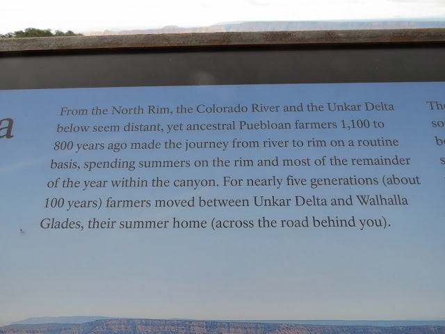
This Life Style Seemed To Be The Same Throughout All The Areas I Have Visited. On My Last Visit To The South Rim I Had Some Photographs Of Caves Possibly Used By The Indians. The Interesting Thing About It The Stories Told About What The Caves Were And What They Were Used For Were Entirely Different Than This. I Tend To Believe This Is The Real Story. It Is Consistent With What I Have Found Through Out The Area. Often Times Stories Told By Guides And Tour Pilots Are Just That " Stories That Sound Good "  For The Tourist But In Fact Do Not Tell The True History Of The Canyon And Its Early Inhabitants. Excavation In The Canyon Floor Have Found Numerous Caves And Structures They Built To Stored Their Grain.
Delta Area Where Indians Lived Part Of The Year
Large Rock Formation In The Canyon
Colorado River.
Living Delta To Rim
Enlargement Of Living Delta To Rim
Unkar Delta Is A Flat Piece Of Land In A Bend Along The Colorado Rover In The Bottom Of
The Grand Canyon
View Of The Canyon With The Colorado River Flowing By Unkar Delta
Enlargement Of Unkar Delta Where Ancient People Farmed
Prehistoric Life On Walhalla Plateau
Enlargement Of Living Delta To Rim
Discovering The Past
Archaeologists Excavating Ruins At Unkar Delta
Hundreds Of Pine Cones Under Ponderosa Pine Tree
Sign Pointing To Cape Royal. It Is Roughly 26 Miles One Way From The Grand Canyon Lodge Area
To This Point Then There Is A Long Trail That Is Fairly Flat That Goes Out To Several Viewing Points
And Goes Through Widely Different Plant And Tree Life Than In Other Parts Of The Park.
Sign Telling About Plant Life
Big Sage Brush And Its Uses
Big Sage Brush
Cliffrose
Cliffrose
Cliffrose
Angels Window
Looking At The Colorado River Through The Angels Window. From The South Rim You Don't Even Know This Exists.
View Of The Rock Ridge In Which The Angles Window Is Located. Note The Overlook View Point
On Top The View From That Point Is Unbelievable.
View Of Canyon From Atop Of Angles Window
View Of Canyon From Atop Of Angles Window. Marvelous View.

Looking Into Side Canyon Near Angles Window
View Of Canyon Near Angles Window
Pinyon Nuts
Pinyon Pine Trees
Utah Juniper
Utah Juniper
Sapsucker Woodpecker At Work On A Juniper Tree
Advise On What To Do When Lightening Is In The Area.
Another View Of The Colorado River. The Unkar Flat Is In The River Bend To The Right. I Think The
Unkar Creek Is Visible To The Right Of The Big Rock Formation Beside The Unkar Flats.
Canyon View And Colorado River
Canyon View. Note The Bare Dirt Beyond The Big Rocks. That Is Caused By People Standing There Trying To Get A Better View. Very Dangerous.
Marvelous Rock Formation. Isn't It Amazing That The Trees Are Growing All Over These Formations
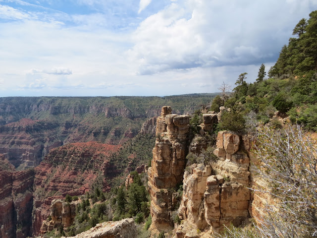
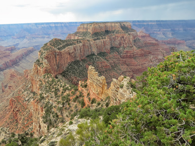
The Views Of The Canyon And The Colorado River Are Spectacular From The North Rim
View Of Canyon
    View Of Canyon. Just As I Took The Photograph Above My Camera Flashed On A Warning That My         Battery Was Depleted. So I Turned It Off And Headed Out Of The Park. I Wrote In My Notes That          " Camera Battery Is Out So Head Back To Motel. I Am Finished Anyway  " Which Was Accurate As I
Was Ready To Leave As I Had Seen All The View Points And Taking The Trails I Could Take But
Not All The Trails I Wanted To Take.  Actually I Guess My Real Feeling Was That I Wished I Had A
Lawn Chair And The Time To Just Sit For Hours Looking At The View And Seeing Something New
Every Second. The Steep Winding Road Through The Forrest As You Come Down Into The Valley
Is Beautiful. 
When I Got Down To The Area Where The Large Meadows Are On Both Sides Of The Road I 
Couldn't Believe My Eyes Because There Was This Large Herd Of Buffalo Grazing In The Meadow. 
I Stopped And Turned The Camera On Because I Have Learned That After Turning It Off For A While 
You Can Usually Get A Couple Of More Shots And The One Above And Following Are Those Shots.
I Pulled Off The Road And Just Watched These Buffalo For A Few Minutes

So now I start the long beautiful drive back to the motel. As I went by the Vermillion Cliffs I stopped at a couple of pull off points to take a few more picture but the battery was truly depleted and no amount of rest was going to work so you will never see what I saw. So sorry. I got back to the motel at 7:32 local time. I washed up and went to partake of the excellent salad bar here. Tomorrow is another busy day as I head for Zion National Park and really head west at that time. I have enjoyed my stay at this motel.

Remember God loves you and so do I.

Today's Comment:

" They that sow in tears shall reap in joy. " Psalm 126:5.

Grandpa Bill