Today is Aug 21, 2013 and I am eating my favorite breakfast a large fruit bowl at my motel the
Best Western East Zion Thunderbird Lodge in Mount Carmel, Utah. Yes, I had my favorite booth so I
could watch the hummingbirds eat. After filling Lady Blue up with gas at the motel's gas station I hit the road for the Grand Staircase Escalante National Monument and the Capital Reef National Park. So I have a lot of driving to do today. I take the same route I took to go to Bryce Canyon National Park in fact I drive right by the entrance and keep going on route 12 for another 41 miles to Escalante. Most of this route is called scenic route 12 on tourist maps, etc.

Early Morning And The Moon Is Just Setting At 7:26 A. M.

Telephoto Shot Of The Moon As It Goes Down At 7:27 A. M.

I Love This Photo. Four Hummingbirds Sitting On Feeder Eating With Two More Hovering About
To Come In To Eat.

Closer View Of The Four Birds Shown Above One Is Closer To Landing To Eat.
The Grand-Staircase Escalante National Monument is a vast area comprising nearly 2 million acres of land in southern Utah and nearly as large as the state of Delaware. It borders on the south with the Glen Canyon which I visited a few days ago as well as the Grand Canyon. It is vast and encompasses some of the most remote areas of the nation. A testimony to its size is the fact that it has four visitor center and one information center. It is made up of three different areas; namely, Grand-Staircase, the Kaiparowits Plateau, and the Canyons of the Escalante. The area was designated as a National Monument in 1966 by President Clinton. The area has significant geological discovers that have been made with the discovery of several dinosaur remains. Some of the types of dinosaur discovered have been found no where else in the world.The area has many arches, natural bridges, hoodoos, spires and peaks many of which are extremely difficult to reach. New discoveries are being made yearly. For example they have discovered 15 to 20 honey bees that exist no where else. Also other discoveries include the finding of shark teeth and various shell creatures found only in the oceans. The Monument was declared a National Monument during the presidential election campaign of President Clinton and was controversial from the moment of its creation. The declaration ceremony was held at Grand Canyon National Park in Arizona, and not in the state of Utah. The Utah congressional delegation and state govenor were notified only 24 hours in advance of the ceremony. That November, Clinton won Arizona by a margin of 2.2 percent, and lost Utah to Republican Bob Dole by 21.1 percent. There are still points of contention between Utah and federal authority over portions of the land and roads in the monument.
Humans did not settle in the area until around A. D. 500 with the arrival of the Basket makers. Both the Freemont and ancestral Puebloan people lived here. The Freemont people hunted and gathered in the area below plateau and near the Escalante Valley while the ancestral Puebloan people farmed in the canyons. Both groups grew corn, beans, squash and built brush roofed pit houses as well as natural rock shelters in the cliffs. The Southern Paiutes and Navajo Indians lived in the area later as well as the Hopi.
The first white settlers date back to 1866 when Captain James Andrus led a cavalry group to the headwaters of the Escalante River. Mormons settled in the area as they moved west and built homes and farmed the area. They established ranches and raised cattle. Some of these ranches still exist. Some of the information available at the parks indicates that current residence in the area who have lived here all their lives acknowledge how hard life is but it is home and they would not want to live anywhere else. A little later are several photographs of a park display telling about one such group of Mormons coming to the area.
I have always wondered why they called this one area the Grand Staircase. The explanation is that for early people who saw the area said the various levels of the territory actually looked to them like a stair case so the name stuck. Looking into this answer a little deeper discloses that the stair case is actually composed of five different layers of rock with each layer a little higher and resting on the layer below it. These layer are from the lowest of 5,000 feet elevation and increasing to the last and highest of over 10,000 feet elevation. The first or lowest level is known as the Chocolate cliffs which are brown in color. Then the Vermilion's cliffs reddish in color. Next are the White cliffs. Then the Gray Cliffs and finally the Pink Cliffs. Together they form a section of rock several miles long and over 7,000 feet thick.

Grand Staircase-Escalante National Monument Information Center

Information Center Garden Area

A Glass Of Water Was A Wagon Load

Explanation Of What A Water Lizard Was. The Paira River Also Ran Through Bryce Canyon Where I
Was Yesterday.

Photo Of A Water Lizard Which Was A Sled With A Barrel To Haul Water

Great Basin Collard Lizard- See Next Photo

Great Basin Collard Lizard Hope I Don't Happen Upon Him. Ha.

Reptilian Mystery. The Eastern Collard Lizard Is The Small Lizard Sitting On The Rock And The Great Basin Collard Lizard's Feet Seem To Be Holding The Rock In The Above Photo

Grand Staircase-Escalante National Monument Sign

Grand Staircase-Escalante National Monument Visitor Center. I Visited The Displays They Had And Filled My Water Bottle With Fresh Water And Bought A couple Of Items.

Historical Information

One Wild Wagon Trip
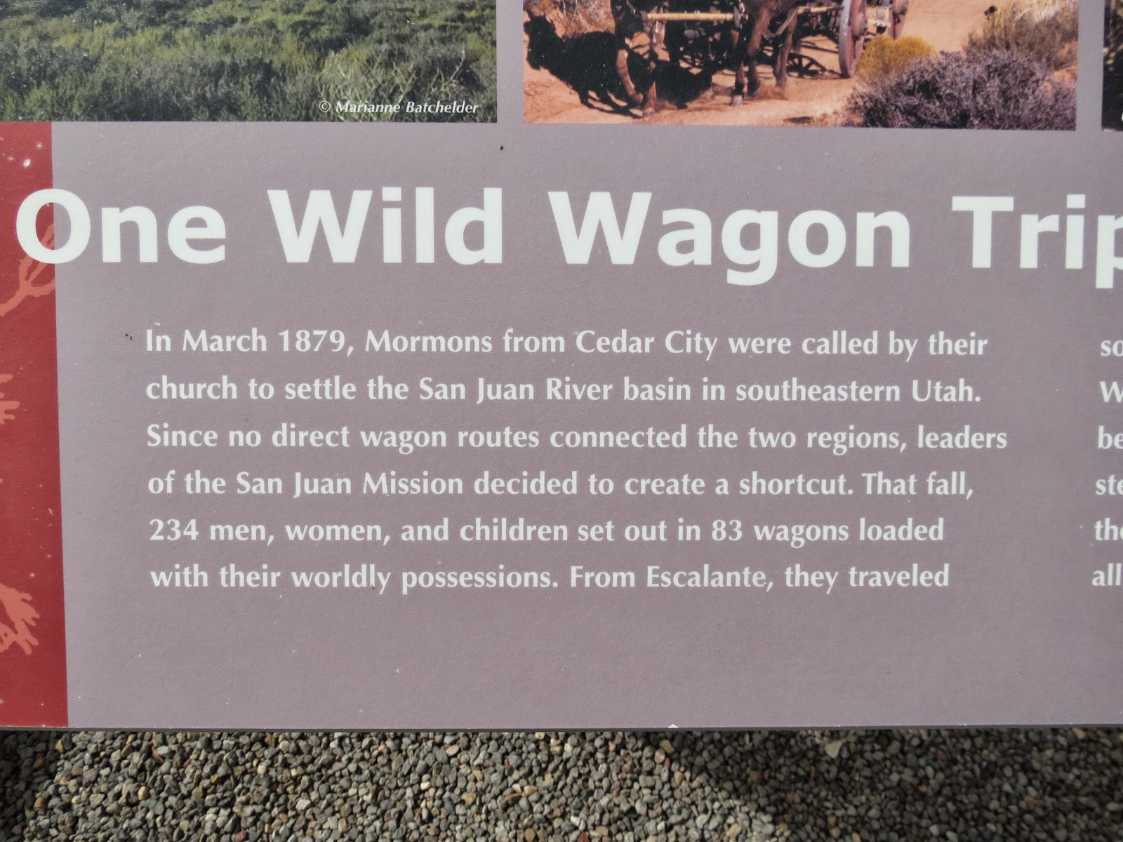
Enlargement Of One Wild Wagon Trip

Enlargement Of One Wild Wagon Trip

Long Journey Stopped Short Of Goal

Dance Hole Rock

Henry Mountains

Navajo Mountain Water Flow Carved Rainbow Arch At Glen Canyon Area

Major Land Features

Major Land Features. Notice The LaSal Mountains I Saw Them At Arches National Park

Major Land Features

The Last Frontier

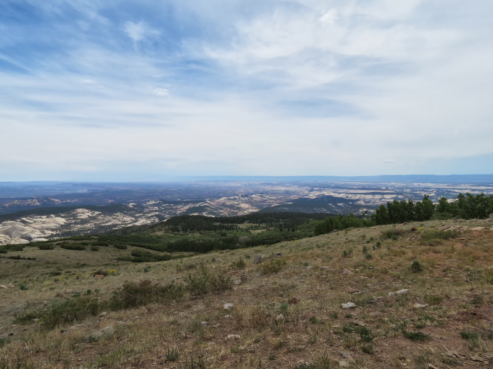
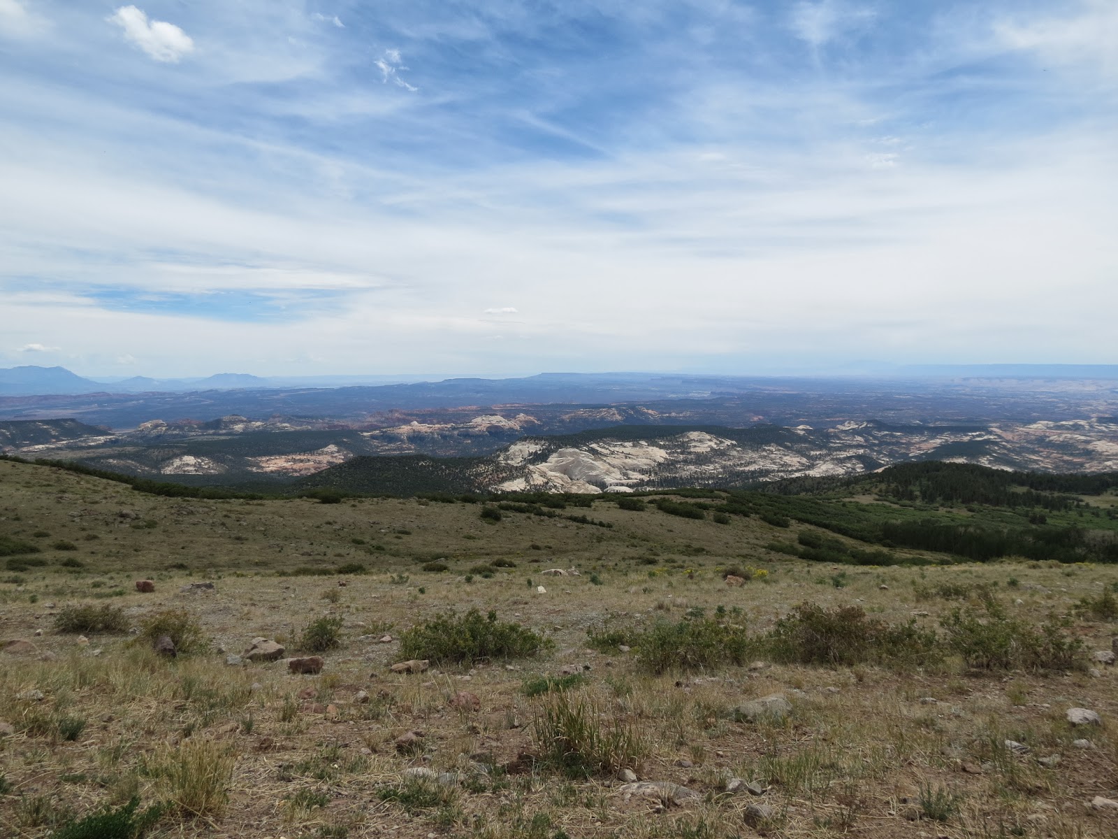
Looking Out Over This Vast Area

Looking Out Over This Vast Area. Note The Highway Below And To The Right.

Looking Out Over This Vast Area. You Can See The Highway I Am Driving On In The Middle Of The Photograph. Can You Imagine Years Ago Traveling Across This Country In Wagons Pulled By Mules
And Horses.

Building A Million Dollar Road

What Was The CCC? It Is Interesting That Few People Today Know What The CCC Was And What It Did. Extremely Important Work Was Done By These Workers All Across The Nation And At The Same Time Provided Work And Income For People In Desperate Need.

Cream Cellar Route

Roads Were Desperately Needed

Million Dollar Road

Building Million Dollar Road

Mixing Concrete The Hard Way As They Build A Million Dollar Road

Escalante River Wild Life And Trees

Cotton Wood Trees

Escalante Canyons Supported Life

Escalante River Wildlife

Escalante River Information

Someones Home. The Escalante River Is To The Right Of The Highway And Trees. This And Some
Of The Following Photographs Were Taken From An Overlook Describing The Million Dollar Highway And Looking In About 360 Degree Around The Overlook.

Very Rugged Terrain

Rugged But Beautiful

Rugged But Beautiful

It Is Hard To See But Down In The Valley Between The Mountains There Is Green Farm Land
And Homes

Looking Over The Edge Of The Overlook Down Into The Gorge. Notice There Is No Protective Railing

Welcome To Boulder, Utah. It Seemed Like I Drove Forever Before I Came To This Town. As You
Drive You Don't See Houses Just landscape. Also There Was A Lot Of Construction Going On The
Road They Were Resurfacing The Road. I Was Concerned About Getting A Lot Of Road Tar On
Lady Blue But Did Not. They Were Laying A Layer Of Tar And Then Spreading A Thin Layer Of
Small Gravel On Top Of It. It Seem To Dry And Harden Rapidly And Was Smooth. On The Return
Trip To The Motel I Drove Over Some Of The Resurfaced Sections Of Road And They Were Nice. It
Was Lunch Time And I Found The Only Place To Eat They Had In Bolder And Had A Nice Cheese Burger. This Place Had A Old West Cowboy Decor Throughout.

Boulder Mail

Early Mail Delivery

Horse Drawn Wagons. Look At The Conditions They Had To Endure. Imagine The Wear And Tear
On The Horses And The Wagons. Not A Smooth Ride.

View Of A Valley From An Overlook On Way To Capitol Reef. At Torrey,
Utah I Turned Right On Highway 24 Which Goes Into The Capitol Reef National Park.
View From An Overlook On Way To Capitol Reef
View From An Overlook On Way To Capitol Reef

Capitol Reef National Park Visitor Center. I Visited The Visitor Center And Bought A DVD
What is Capitol Reef all about? From a geological point of view it is the Waterpocket Fold that define Capitol Reef National Park. A stretch almost 100 miles long has a warp in the earth's crust and is a classic
monocline. This is a situation with one very steep side in an area of otherwise flat land. The early pioneers gave the name of " Capitol " because the white domes of the Navajo Sandstone that resemble the capitol dome in Washington, D. C. , and the " reef " for the rocky cliffs that are a barrier to travel, like an ocean reef. Almost 10,000 feet of sedimentary strata ( rock ) are found in Capitol Reef. As far a human history is concerned it is much the same as found throughout the larger area.. The " pockets " of the " Waterpocket Fold " are natural basins for holding water from rain and snow melt. The fertile land along the Freemont River and Sulphur Creek coupled with these water pockets as well as wildlife that attracted early human settlers. There is evidence of Freemont culture that was here for about 600 years starting about A. D. 700. They were hunters and gatherers. Around A. D. 1300 they abandoned the area. You will recall in nearly all the parks I visited these Native people abandoned their areas about this same time. The general reason seems to be a prolonged drought that hit the area but there is no positive evidence for sure that this is what happened. As in other areas there are Petroglyphs ( carvings in rocks ) as well as Pictographs ( paintings on rocks ). Several hundred years past before Capitol Reef saw permanent human settlers. Mormon Settlers came to the area in the late 1880's and set up a settlement near where the current visitor's center is located. Using water from the Freemont River they planted crops and orchards while ranchers had cattle in the Waterpocket Fold. These pioneers stayed here for less than 100 years. President Franklin Roosevelt proclaimed the area a National Park Service National Monument in 1937 the last residence left the area in 1969. In 1971 congress designated the area a national park.
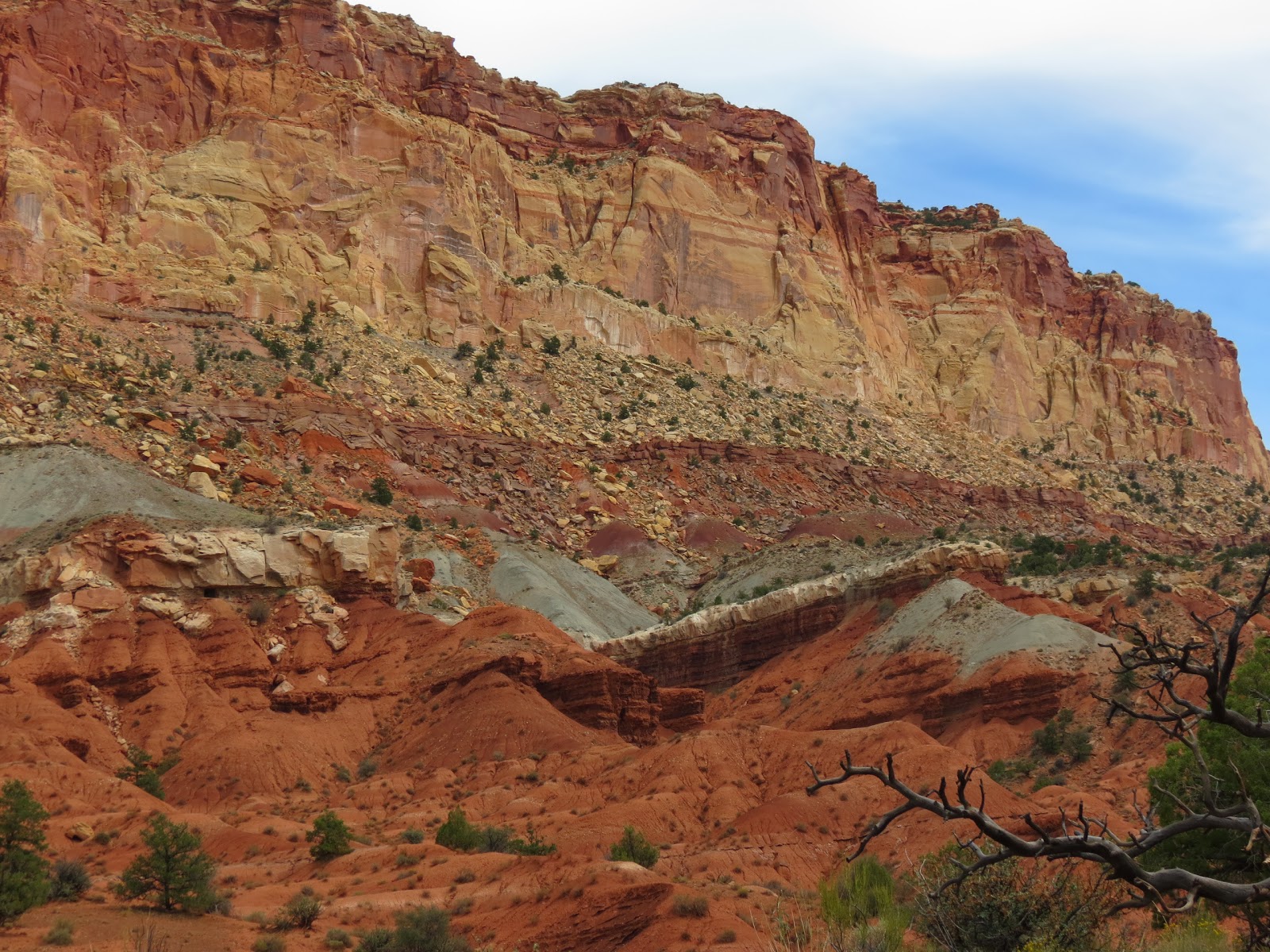
As you enter the park from the west you see the 1,000 feet high cliffs ( barriers ) which have been eroded into numerous canyons, mesas, buttes and mazes. I took the 16 mile round trip loop drive and saw some fantastic sights. Like many of the parks some of the more spectacular sights can only be accessed by longer trails or with four wheel, high clearance vehicles. Remind me to pull a four wheeler behind Lady Blue the next time Ha. I had planned to take two of the trails but did not. One was at the end of a dirt road that had a recommendation of travel only for high clearance vehicles. The other because it was raining a little and the skies looked threatening so I did not want to take a chance as there were very few other people around.

Waterpocket Folds

White Cliffs

Hickman's Arch

View In Capitol Reef On Loop Drive

View In Capitol Reef On Loop Drive

View In Capitol Reef On Loop Drive

View In Capitol Reef On Loop Drive

View In Capitol Reef On Loop Drive

View In Capitol Reef On Loop Drive

View In Capitol Reef On Loop Drive Of Capitol Dome

View In Capitol Reef On Loop Drive

View In Capitol Reef On Loop Drive

View In Capitol Reef On Loop Drive

View In Capitol Reef On Loop Drive

View In Capitol Reef On Loop Drive
View In Capitol Reef On Loop Drive

View In Capitol Reef On Loop Drive

View In Capitol Reef On Loop Drive

View In Capitol Reef On Loop Drive

View In Capitol Reef On Loop Drive. Look At The Many Layers Of Different Material There Is In This Cliff.

View In Capitol Reef On Loop Drive

View In Capitol Reef On Loop Drive

View In Capitol Reef On Loop Drive See Five Photographs Later To See Coming Back Through
This Rock Formation

View In Capitol Reef On Loop Drive. You Can See One Of The Trails And A White Marker In The
Lower Middle Of This Photograph.

View In Capitol Reef On Loop Drive Large Side Canyon.

View In Capitol Reef On Loop Drive

View In Capitol Reef On Loop Drive. Two Girls Trying To Take A Picture Of A Ground Squirrel. They Were With A Family Camping Here. During My Time In The Park I Only Saw Two Other Cars And This Family Which Had An Air Stream Trailer

View In Capitol Reef On Loop Drive. This Was A Low Spot In The Road Which Was In Places
Among These Rocks Covered With Wet Sand From A Recent Rain. I Am On The Way Out On The
Return Portion Of The Loop Road. Five Photographs In Front Of This One Shows The Road Entering
This Rock Formation.

View In Capitol Reef On Loop Drive. Sky Looks Like Rain

View In Capitol Reef On Loop Drive

View In Capitol Reef On Loop Drive

View In Capitol Reef On Loop Drive

View In Capitol Reef On Loop Drive. Good View Of The Different Colored Layers Of Rock

View In Capitol Reef On Loop Drive. This Is Open Range Country. The Car In Front Of Me Did Not Seem To Want To Give The Cattle The Right Of Way. Not Sure What He Was Up To.

View In Capitol Reef On Loop Drive. One More Stray Cow. At This Point My Battery In The Camera
Ran Down So There Will Be No Photos Of The Return Trip To The Motel In Mount Carmel, Utah Quite
A Distance Away. The Sky Looks Like I May Have To Drive Through Some Rain Before I Get Back
Well it is 7:05 P. M. and I have had a long drive back to the motel and am ready to have my salad bar dinner and tonight I feel like a bowl of soup also as I watch the Hummingbirds eat. I have another busy day tomorrow as I drive to the Vermilliom Cliffs and on to the North Rim of the Grand Canyon. That is a long drive and a lot of walking.
As I always remind you God loves you and so do I.
Today's Thought is: One day is with the Lord as a thousand years; and a thousand years as one day. II Peter 3:8.
Grandpa Bill
No comments:
Post a Comment