
Humming Birds Having Breakfast

Beautiful Hummingbird

Hummingbirds Hovering Around Feeder

Hummingbird

Four Hummingbirds Eating Among Large White Trumpet Blossoms
After breakfast I start out on Highway 89 headed for Bryce Canyon National Park. The road goes through a valley with lot of farm land with cattle and fields of alfalfa. All field had irrigation systems that were in use. There are large mountains on either side of the valley. After about 40 miles I turn to the right on Highway 12 which leads to Bryce Canyon National Park but first it goes by Red Canyon and a lot of beautiful country.


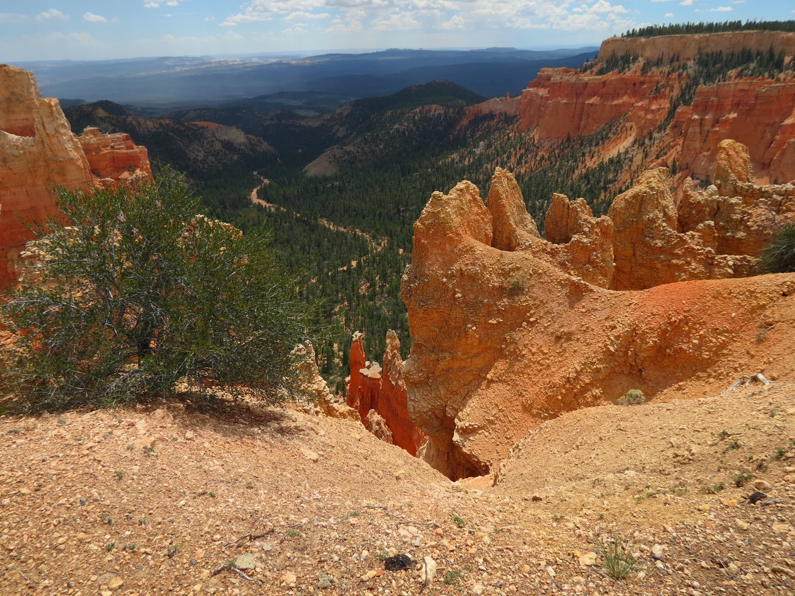
Hillside Near Red Canyon

Hillside Near Red Canyon

Hillside Near Red Canyon Gives A Small Preview Of What Bryce Canyon Will Look Like.

Hillside Near Red Canyon. Interesting Formations

Tunnel Through Rock Formation On Way To Red Canyon And Bryce Canyon

Red Canyon Visitor Center. Looked At The Displays And Got A Stamp In My Passport Book And
Talked To The Volunteers Manning The Visitor Center. Red Canyon Is Managed By The U. S.
Department Of Agriculture
Red Canyon is located in the Dixie Forest which is large, two million acres and stretches 170 miles from Red Canyon To Cedar Mountain. This distance covers dessert scape of red sandstone to lush high altitude forest.
History and lore of the old west are alive in Red Canyon, thanks to Butch Cassidy, who was raised nearby in a cabin in Circleville where he lived from 1879 until 1884 . Rumor has it that when Cassidy was in Panguitch at a dance he got himself into a brawl over a girl. Cassidy thought he killed the fellow and fled to the craggy land where Red Canyon is today. Turns out the man was just knocked out and was just fine, but a posse was already sent out after Cassidy. He eluded them by hiding along what is now known as the Cassidy Trail. The elevation along the trail is approximately 7,200 to 8,000 feet. It seems there is more than one story that goes along with all of the remote park areas. Panguitch is a tourist attraction but I did not go see it.
Back to reality. For centuries, bands of Southern Paiutes lived near Bryce Canyon.They hunted and fished on the top of the plateau while living in the warmer valleys. Little is known of these people because they left few artifact behind. Little is known of other humans in the area in early times. The Kanarra Cattle Company used the plateau adjacent to Bryce Canyon for grazing in the early 1870's. In 1875 Ebenezer Bryce, a Scottish immigrant and millwright became the first settler in the area The area was managed by the U. S. Forrest Service in 1915 and efforts were made to prove the area was worthy of being an National Park. In 1919, Reuben Syrett built tourist facilities and became the first postmaster of Bryce Canyon. President Harding in 1923 set Bryce Canyon aside as a national monument and it became a national park in 1928. The Rim Road was constructed by the Civilian Conservation Corp in 1934 and by 1942 the park reached its present size of 35,835 acres. Even in the state of Utah the park was not widely known at first. In the 1920s to 1930s the Union Pacific Railroad built a lodge in the park and provided transportation to the area as well as running an extensive advertising campaign.
Bryce Canyon has been described as one of the world's geologic masterpieces with its pinnacles, spires and eroded stones that stand in fields like bizarre statuary that never seem to appear the same twice. Part of the reason for this is that the views change throughout the day as the sun shines on the rock and then the shadows that they cast change the view. Add to this the change that is caused by the a shower of rain. These stones are soft and are constantly being eroded by rain and well as freezing and thawing conditions. I was a little surprised by the amount of rain and snow the park gets. The park gets rain every month ranging on average from less than an inch each of three months to over an inch in eight months. As for snow the park receives on average 10 to 18 inches in five months lesser amounts in five months and none in two months. High temperatures average in the 85 to 92 in five months. It was 90 or so when I was there but cooled off due to rain showers. I was unable to be at the park to take any sunrise or sunset photographs.There was one pretty heavy rain shower but fortunately I was just going into the lodge to get something to eat and it stopped by the time I came out an hour or so later. There are numerous trails in the park that vary from fairly short and classed as easy to longer ones which are classed as strenuous. One ranger led trail that would be wonderful happens on nights when there is the full moon. Another popular activity that the park is ideal for and that is star gazing. Information at the park indicates that on a moonless night the light from Venus causes you to cast a shadow and even with out a telescope you can see 7500 stars. I was impressed that the park uses a amber colored light to allow better star gazing and even these are on motion detectors and turn off when not needed . I will have to go back some day to witness this.

Bryce Canyon National Park

Bryce Canyon National Park Visitor Center

Predator Of The Predators

Predator In Action

Just Look At The Size Of This Monster
While in the visitor center I visited the gift shop and made a couple of purchases, got my passport book stamped and talked to the rangers about the trails and which ones I should tackle. I wanted to walk the Navajo Loop Trail which has its trail head at Sunset Point. This trail is 1.3 miles long and goes through two slot canyons with views of the Two Bridges, Thor's Hammer and the Wall Street formations. The ranger recommended starting down the less steep trail and coming back up the very steep trail. That would permit me to stop and come back up the less steep trail if I got too tired to tackle the steep trail. By steep I mean a change in elevation of of 521 feet in a very short distance with many, many switch backs in the trail.. Then I drove to the Sunset Point.

Sunset Point

Showing The Routes Of Major Trails From Sunset Point.

Views From Sunset Point

View From Sunset Point. The Dark Area In The Lower Left Is Actually Where I Wanted To Go But Coming From The Other Direction

View From Sunset Point. The Trail I Wanted To Be On Came Through The Valley With All The Trees.

Trail Which I Am On. I started at 10:15 A. M. This Is About A Hundred Yards Down The Trail. At This Point I Need To Explain That Back A Hundred Yards At The Start The Trail Split. I Wanted To Take The Less Steep Trail To The Left Which Would Have Taken Me To The Valley And Brought Me Back Up The Very Steep Trail Through This Arch But For Reasons I Cannot Explain I Took The Trail To The Right.

View From Sunset Point And From The Start Of The Trail I Am On.

View From Sunset Point And From The Start Of The Trail I Am On. Beautiful. Beautiful.

Going Down. You Can See About Nine Switch Backs In The Trail And At Least 10 People On The Trail. You Notice There Is No Railing On Your Left As You Walk Along. Fall Off To The Left And You Better Yell Out " Watch Out Below "

View From The Trail. Look At The Beautiful White Formations.

View Into The Valley From The Trail I Am On. Beautiful Colors.

View From The Trail I Am On Of The Famous Hoodoos. There Is A Small Arch In The Lower Left And Brilliant White On The Right. I Think The Single Formation In The Front Middle Is Thor's Hammer. I Will Tell About Hoodoos Later.

The Views From The Trail Are Spectacular. It Is Amazing That Trees Have Been Able To Take Root
And Survive In This Area.

More Views From The Trail. In The Middle Of The Photograph You Can See Where The Park Service Has Had To Build A Wall To Support The Trail Where It Has Washed Out.

More Views From The Trail

These Folks Are Almost At The Bottom. In This Photograph You Can Get A Better Perspective Of The Vertical Nature Of This Trail. Notice The Man At The Bottom Helping His Partner. I Am Standing
Perhaps A Hundred Yards Above Them

Views From The Trail

Views From The Trail

At A Point About Half Way Between The Woman On The Left Who Is Caring A Child In Her Arms And The Man On The Right Who Is Bent Over Climbing Back Up The Hill My Time On This Trail Came To An Abrupt End. I Was Almost To The Bottom And I Stepped On A Slick Spot Of Loose Gravel And Sand And Even With My Walking Stick I Could Not Keep From Sliding Down. That Is What I Did. I Did Not Fall Down I Slide Down And My Walking Stick Was Sliding Also. Now At This Point The Trail Was Very Steep And My Thighs Were Burning Like Fire. It Is Harder To Go Down Hill Than Climb Up Hill. I Had Been Stopping To Rest Every Couple Of Switch Backs. When I Slid Down I Completely Tore The Rear End Out Of My Pants. I Could Feel The Small Rocks And Gravel Pressing Into The Skin. When I Tried To Get Up My Legs Would Not Lift Me. My Knees Also Felt So Weak. You Have Seen From The Photos That There Are A Lot Of People On The Trail And Quickly There Was A Road Block In The Trail And That Was Me. Some People Stepped Over Me And Kept Going Up Or Down Hill. Others Stopped To Watch The Show. One Lady In Particular Seemed To Be A Take Charge Kind Of Person And She Said I Needed Water And Something Sweet So She Gave Me A Piece Of Candy. I Told Her I Had Plenty Of Water And All I Needed To Do Was Rest A Few Minutes. She Kept Insisting I Needed Thus And So And She Was Going To Call The Rangers. I Asked Her Please To Not Bother Them Because I Was Fine And Only Needed A Couple Of Minutes Rest. Her Husband Kept Telling Her To Stop That I Knew How I Was And What I Needed. I Had Managed To Kind Of Get Out Of The Way So People Could Get By And Soon I Was Alone. At This Point I Did What I Often Do In Bad Situation I Ask God For Help And He Did. I Took My Walking Stick And Making Sure It Was On Solid Ground I Used It To Climb / Pull Myself Up Into An Upright Position Where I Stood For A Couple Of Minutes. When I Was Sure I Could Walk I Abaonded My Walk To The Bottom And Started Back Up Hill. I Stopped Every Couple Of Switch Back And Sat Down To Rest. On This Trail The Park Service On Most Of the Switch Backs Had Built A Low Retainer Wall On The Uphill Side Of The Trail To Help Control Erosion And Prevent Wash Out The Trail. In Some Places These Walls Make A Good Place To Sit Down And Rest. By The Time I Was About Three Quarters Of The Way Back To The Top I Was Feeling Stronger Except For My Thighs. As I Neared To The Top I Saw A Guy Heading Downhill Who After He Passed Me I Thought He Does Not Look Like A Tourist. He Was Walking Fast And Had Already Gone A Couple Of Switch Backs And I Yelled To Him And Asked Him If He Was Responding To A Request To Assist A Old Guy Down Near The Bottom And He Said He Was. I Told Him I Was That Guy And I Was OK. He Turned Around And Came Back Up Pass Me And I Did Not See Him Again. I Thought Thanks For Giving Me A Hand The Rest Of The Way Back To The Top Although I Did Not Need Any Help. It Was A Major Disappointment For Me Not To Make It To The Bottom But He Most Troubling Thing Was trying To Figure Out How I Took The Wrong End Of The Trail. After Having Gone Down The Steep Trail And Back Up It I Have No Doubt I Could Have Easily Done The Entire Loop If I Had Gone The Right Way To Begin With. What Is The Old Saying - If Wishes Were Horses Beggars Would Ride Or Something Like That. But One Thing I Have Learned In Life And That Is Not To Spend Time Wondering Why. God Had A Reason And I Am In No Position To Question Why. On The Way Back To The Top I Got Some More Wonderful Photographs.

Nearing The Top. Notice Three People On Different Levels Of The Trail

View Nearing The Top Of The Trail

View Looking Back Down The Trail. These Are Vertical Cliffs Of Red Sand Stone.

More Cliffs Near The Top

Looking Back Down The Trail Near The Top. It Is Interesting At Some Points You Can See Way Down The Trail And Others Like This One You Seem To Be Looking Into A Large Dark Hole.

Nearer The Top Of The Trail. Here You Can See Twelve Or So People On The Heading Up. The
Person Closest To You Has Stopped To Rest And Was Really Struggling To Make It .

Final Look Back Down The Trail. The Lady In Red Has Stopped To Rest.

Final View Of The Walls Of The Canyon From The Trail.

Final Push To The Top. You Can't Tell From The Photo But People Are Really Moving Slow And
Just Barely Putting One Foot In Front Of The Other. At The Top Right You Can See A Hand Rail
And Fence So This Is The Top.
Just Barely Putting One Foot In Front Of The Other. At The Top Right You Can See A Hand Rail
And Fence So This Is The Top.
On The Climb Back Up I Kept Feeling My Rear To Determine How Exposed I Was Back There. All I Could Tell Was The Seat Of The Pants Was Gone. At The Top I Looked At The Trail Signs To Try And Figure Out What I Had Missed. I Could Not See Any Obvious Directional Sign I Had Missed And At This Point All I Was Interested In Was Getting Back To The Car And Getting A New Pair Of Pants. On The Way I Passed An Older Oriental Couple Seated On A Park Bench And They Asked Me To Stop And Sit Down Which I Did. I Think I Wrote About This Couple In An Email Or Travel Update. They Were From California And Just Wanted To Talk And To Know About Me. So I Told Them All About Me And What I Was Doing. They Were Amazed I Was Traveling All Alone. After A Few Minutes Chit Chat I Went On To The Car Got A New Pair Of Pants And Changed. Sure Enough I Was Completely Exposed On The Back Side. It Has Started To Shower And I Am Getting Hungry So I Headed For The Bryce Canyon Lodge To Get Something To Eat. By The Time I Get There It Is Raining Hard With A Lot Of Thunder And Lightning. I Had To Wait A Long Time To Be Seated Because The Rain Drove Everyone Else In. The Park puts Out A Lot Of Information About Safety And Being Safe When There Is Lightning Around. Their Advise Is To Start Counting To 30 When You See A Flash Of Lightning. If You Cannot Count To 30 Between Seeing The Flash And Hearing The Thunder Then It Is Not Safe To Be Outside. They Point Out That In The State Of Utah Bryce Canyon Is The Second Most Common Place for Lightning Fatalities And Injuries. Bryce Canyon Has The Highest Lightning Hazard Density In The State! Considering This And The Fact That It Is Still Showering I Will Just Drive Around And Look At The Park And If It Looks Safe I Will Get Out At Overlooks And Take A Few Pictures.


 The Geology Of Bryce Canyon
 The Geology Of Bryce Canyon
 The Geology Of Bryce Canyon
 The Geology Of Bryce Canyon
 The Geology Of Bryce Canyon
 The Geology Of Bryce Canyon
 The Geology Of Bryce Canyon
 The Geology Of Bryce Canyon
 View At Rainbow Point
 View At Rainbow Point
 View At Rainbow Point
 View At Rainbow Point. The Shapes Are Endless And Just Breath Taking. I Could Stand Here For
Hours Looking At These Beautiful Sites And See Something Different Every Time I Look. More
Excellent Examples Of Hoodoos.


Paria View Overlook

View From Paria View Overlook. Look At The Many Colors

Deep Valleys And Many Different Colored Layers Of Rock

Beautiful. These Are Example Of Hoodoos. The Light Colored Stone On Top Of The Spires Is Lime
Stone Which Is Very Hard And It Protects The Softer Sandstone From Crumbling

From Paria View There Are No Trails But You Can See Trails And A Road In The Valley Far Below. There Is Also A River In he Valley. I Do Not Know If It Has Running Water All The Time.
Another Photograph From Paria View

Beautiful Rock Formations

Looking Deep Into The Valley.The Green Of The Pines Contrasts So Nicely With The Red Sand Stone

Paira View Canyon Wall

Slight Enlargement Of Canyon Wall At Paria View Showing Spires And Hoodoos.

Threatening Storm Clouds Appearing Over Paria View

Enlargement Of Areas Of Hoodoos With Lime Stone Caps. You Can See The Areas Of Red Sand
That Washes Down The Canyon Wall When It Rains And The Sand Stone Crumbles.

Layer Of Lime Stone Rock

Lime Stone Spire. This Was The Highest Point At Paria View.
 I Have Now Driven A Short Distance To Bryce Point. Notice The Elevation.

 From Here You Can See The Paria View Overlook Where I Was Just Located, Great View.
 Looking Into The Valley From Bryce Point
 Natural Bridge
 Natural Bridge
 Another View Of Natural Bridge
 View Around Natural Bridge. It Is 58 Degree And Has Cooled off A Lot With The Rain Which Is
Pretty Steady.
 This Is A Perfect Example Of A Large Hoodoo You See The Layer Of Lime Stone On Top Of The
Red Sand Stone Then In Front Of The Hoodoo You See The Large Layer Of Lime Stone.This
Photograph Is At Agua Canyon Overlook
 View To The Right Of The Large Hoodoo
 High Plateaus Of Utah
 Information About The High Plateau Of Utah
 You Can See From This Photograph That The Canyon Is Just A Large Valley Now To The Left
Of This Cliff. This Photograph Is From Rainbow Point Where The Elevation Is 9115 Feet The Highest Elevation In The Park.
 A Better View Of The Valley From Rainbow Point
 Surrounding Area Off In The Distance
 Looking Down At Spires
 The Geology Of Bryce Canyon

 The Geology Of Bryce Canyon
 The Geology Of Bryce Canyon
 The Geology Of Bryce Canyon


Another View


Pretty Steady.

Red Sand Stone Then In Front Of The Hoodoo You See The Large Layer Of Lime Stone.This
Photograph Is At Agua Canyon Overlook


Of This Cliff. This Photograph Is From Rainbow Point Where The Elevation Is 9115 Feet The Highest Elevation In The Park.


The Geology Of Bryce Canyon


Hours Looking At These Beautiful Sites And See Something Different Every Time I Look. More
Excellent Examples Of Hoodoos.

As Noted Earlier It Has Rained Off And On All Afternoon. Right Now It Has Stopped And I Am Getting Ready To Head Back To The Motel When I Glance To My Right I See These Large Birds Sitting In These Old Dead Trees. They are Quiet A Distance From Me And No Trail To Get Near Them. I Am Trying To Hold The Camera Good And Steady And Use The Telephoto At High Magnification. The Sun Is Out Now And They Are Sitting There Preening and I Guess Trying To Dry Out. I Asked A Few People What Kind Of Birds They Are And No Body Knew Or Claimed They Could Not See Them. I Grant That They Were A Far Distance Away.

This One Is Sitting With His Wings Open Exposing His Breast To The Sun.

This One Is Sitting With His Wings Opened With His Back To The Sun. I Never Did See Any Of The Birds Fly. There Were Five I Could See. I Thought They Were Condors But I Could Not Find Any Reference in Park Literature That They Exist In This Park. They May Have Been What I Call Turkey Buzzards.

Park Sign Showing That Rainbow Point Is The End Of The Road At This End Of The Park And Is Where The Bristlecone Loop Trail Starts And Ends. This Trail Was One Mile Long And Stays Entirely Above The Canyon Rim Going Through The Trees And I Had Wanted To Walk It But Because Of My Experience Earlier In The Day And The Lateness Of The Afternoon I Decided Not Try It.

Comments About The Bristlecone Trail Forest
This concludes my visit to Bryce Canyon National Park. It has been exceptional day and beyond my ability to describe. I have a long drive back to the motel where I will get me something to eat look at the humming birds and get to bed because I have another busy day tomorrow. Again I ask you to remember that God loves you and so do I.
Grandpa Bill
No comments:
Post a Comment