Today is August 17, 2013 and I left Cortez, Colorado after a good breakfast and headed north for Moab, Utah a distance of roughly 144 miles with stops along the way at the Canyonlands National Park and Arches National Park. The route of travel I am taking is Highway 491 out of Cortez, Colorado to Monticello, Utah and then Highway 191 up to Moab where I have reservation at the Best Western Plus Canyonlands Inn for two nights. All of this route ranges from 4,000 feet to 7050 feet in elevation. This route is colorful and interesting high arid dessert with lots of monolithic formations to see as it goes through the Navajo Indian country. This is open range for cattle. The ground often appears to be level but in reality I am either on a very gradual up climb or very gradual down hill slope. These stretches are miles and miles long and it seems you can see forever. You see what appears to be a mountain range in the distance and you drive and drive and it does not ever seem to get any closer. At the same time it seems with out warning you suddenly start downhill into a canyon with a very steep road, sharp curves and the you are in the valley of a canyon. You are on these stretches of what appears to be level road and you can't see the canyons until you get to them. I know this sounds strange but that is the way it is as compared to approaching a mountain which is sticking up into front of you. About 14 miles north of Monticello, Utah Route 211 turns to the left and goes out to Newspaper Rock State Park about 12 miles and on to The Needles about 36 more miles. This is about 96 miles round trip off Highway 191. There is a ranger station out there. At the junction of 211 and 191 on the right is a large rock formation shown below.


Very Interesting Rock Formation. It looks Like There Is a Tunnel Entrance At The Middle Bottom.
Look At The Different Colored Layers of Rock

Sign About Newspaper Rock National Historic Site And Canyonlands National Park And Listing Of Fees

.Map Of Area

Information About Canyonlands
 Information About Sights To See.
 More Sites To See
 More Sites To See
 More Sites To See. You Could Easily Spend A Week Trying To Explore All Of The Sites Available
 Canyonlands National Park Sign
 Needles Map
 Information About The Needles District
 Moe Information About The Needles
 Large Arch Rock Formation
 Colorado River As It Winds Its Way Through Canyonlands National Park
 Cave Or The Start Of A Natural Arch?
 Information About Canton Rim Recreation Area And The Newspaper Rock Recreation Area
 Close Up Of Information About The Canyon Rim Recreation Area. What The Sign Is True That Some Of The Most Dramatic Views You See Are Before You Reach The Park Area. I Thought I Was In The Park Area But Realized I Had Not Gotten There Yet
 Information About The Newspaper Rock Recreation Area And A Small View Of The Art Of The Ute Indians As Well As The Ancestral Puebloan Indians Some Of Which Is A Thousand Years Old.
 Information About The Manti-La Sal National Forest Which Is On The Left Of Route Of Highway 191 And 211. Part Of his Area Is What I Was Talking About Earlier When Suddenly You Go Down Into A Canyon You Did Not See.
 Information About Newspaper Rock Archaeological Site.


 More Canyon Hill Sides
 You Can See The Road Is Turning To The Left At The Large Hill Ahead And Heads Off Out Into Open Spaces.
 Sure Enough The Canyon Hills Are Opening Up To Wide Open Spaces.
 What A Drastic Change In Scenery Just Look At Those Magnificent Spires
 Close Up Of Previous Photograph. Not Sure How Far That Is Away But It Would Sure Be A Rough Hike. Where I Am Standing Is The Floor Of The Valley Then You See The Tall Spire Is Standing On Another Level Of Ground.
 Same Comments As Above Except To Note That Under Extreme Magnification The Top Of The Spire Is As Flat As Can Be.
 As I Get Closer To Canyonlands National Park You Can See The Dramatic Change In The Hills
And The Different Colors/ Layers Of Rocks In Them.
 You Will See This White Rock Formation More As I Go Deeper Into The Park Which Is Just Ahead.
 After About 30 Miles Or So Finally The Entrance To Canyonlands National Park. You May Recall I Earlier Told You The Scenery Was Spectacular Even Before You Reach The Park. Well, It Was. You Know Sometimes In Seeing All The Beautiful Creations On Gods Earth I Get So Full Of The Beauty I Need To Back Away From It For Awhile So That Is Time For A Stop At The Ranger Station Which Comes Later.
 Bronze Plaque Honoring Bates E. Wilson Who Was A Moving Force That Created Canyonlands
National Park And Served As It's First Superintendent.
As I drove along there would be take me to a camp site or something else to see or there would be road side stops with sign telling about some site that is there and a trail to take to see it. I took many such trails like the following one telling about a Roadside Ruin.
 Roadside Ruin. Is An Ancestral Puebloan Grain Storage Bin. The Sign Says There Are Dozens Of Them In Canyonlands But Very Few Residences Suggesting The People Farmed The Area Heavily But Did Not Live Here Year Round..
 Roadside Ruin Under A Large Ledge
 Puebloan Granary Was Built Between A. D. 1270 And 1295 And Used To Store Corn, Bean
Or Squash Seeds.
 Information About The " Wooden Shoe Arch "
 Close Up Of Information About The " Wooden Shoe Arch "
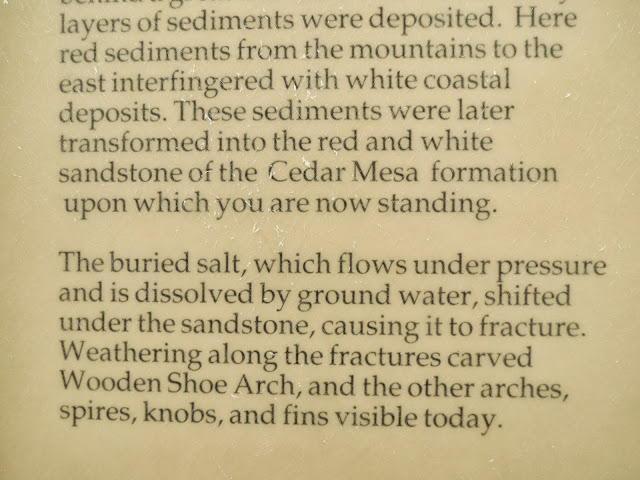 More Close Up Of Information Above
 More Information
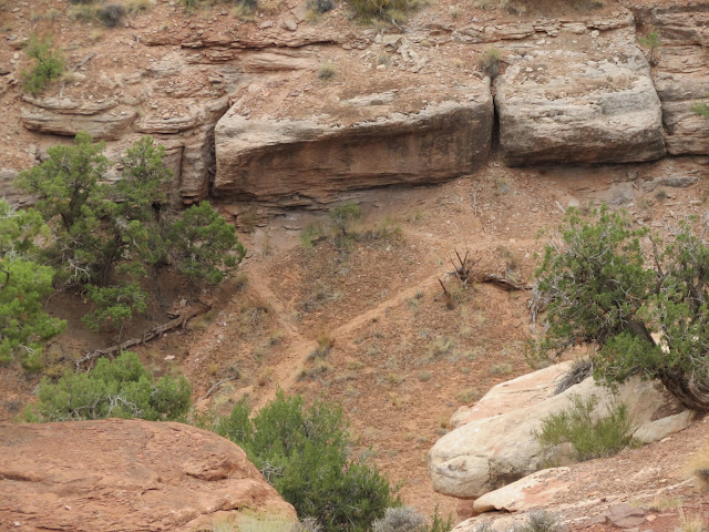
 There It Is As Plain As The Nose On Your Face But A Long Long Way Off.
 OK Do You See It?
 No It's Not There!
 Oh, There It Is Very Plain Through The Telephoto Lens
 It Does Look Like A Wooden Shoe Doesn't It. Now Go Back 3 Photographs And Look At The little Bump Between The Large Hills On Either Side And The Bump Is The Wooden Shoe Arch. You Won't Believe Me But It Is There.
 Sign Identifying This As The Pothole Trail.
 Depressions In Slick Rock That Collect Water And Different Invertebrates Hatch
From Eggs Laid In Them
 Information About Life In The Pot Holes
 Refer Back To Initial Sign Telling About Potholes
 Large Group Of Potholes Filled With Water. I Did Not See Any Life Forms In The Water And I Did Not Touch The Water Or Disturb It. My Trail Leads Off Toward The Trees At The Top Of The Photograph. Looks Pretty Rough.
 More Potholes


You will notice that the above drawings were made from a period of B. C. Time to A. D. 1300 by among others the Basketmakers and Pueblo cultures. These were the people of Mesa Verde which is about 100 miles away to the south whether the exact same ones is not known. Are they telling a story of a group of people or an individuals story is unknown or are they just " doodling ". While I was there there were some ladies from Scandinavia who were visiting. As I talked to them I found they were on a tour of the western United States. They did not speak very good English and they did not understand the word " Doodling ". So you know Grandpa Bill he undertook to explain the word Doodling. Try it some time. I finally by writing on my hand with my finger and a stick writing or drawing in the dirt they finally understood what doodling meant. To illustrate they duplicated what I was doing and said " doodling - yes " and I said yes. Another lesson taught and learned. No telling what they will tell their neighbors and friends when they get back home about this old guy they saw. Oh, well its all in a days touring experience.

Some Of The Petroglyphs At Newspaper Rock. Pretty Crowded Newspaper Isn't It? You Can't See It Without Magnifying This Photograph But There Are A Couple Of Placed Where Modern People Have Added Their Names And Dates.

Top Edge Of Petroglyph And The Large Rock Formation That It Is Drawn On. You Can See That Often Times When These Rock Formations Develop A Crack And Eventually Split Apart They Leave A Smooth Face. Over Time These Faces Have Developed A Dark Surface/Residue Which The Native Americans Used As A Drawing Surface. At Some Point I Was Told ( last year ) I Think That The Crack Filled With Some Mineral Which Hardened And Stuck To The Face After The Rock Split. Not Sure If That Is A Fact Or If I Just Dreamed It But It Sounds Good Except Didn't It Also Stick To The Part That Split And Fell Off? Oh, Well Another Mystery.

Hill As I Drive Toward Canyonlands National Park

More Hills And Beautiful Country

No Shortage Of Rocks On This Hill. Notice How Smooth The Rocks Are.

This Is Open Range So I Don't Know What This Fence Was For Unless It Was To Hold The Small Sign On The Left Post. Not Sure What That Sign Says And I Don't Remember.

Lady Blue Parked In Front Of Large Rocky Hillside

These Rocky Hill Are The Sides Of A Canyon I Drove Through To Reach Canyonlands National Park.


And The Different Colors/ Layers Of Rocks In Them.


National Park And Served As It's First Superintendent.
As I drove along there would be take me to a camp site or something else to see or there would be road side stops with sign telling about some site that is there and a trail to take to see it. I took many such trails like the following one telling about a Roadside Ruin.


Or Squash Seeds.
At another turn out there were these signs telling about a " Wooden Shoe Arch ". I looked and looked and I could not see it. After considerable reading and looking I finally spotted it and then I could not understand why I could not see it at first. After taking the following photographs I went elsewhere but as I was coming back to leave the park I stooped again to look at it and there was a couple there trying to spot the " Wooden Shoe Arch ". I asked them if they wanted me to help them see it or if they wanted to find it themselves. They said I would have to show them as they could not find it and were ready to leave without ever seeing it. I guided their view toward this particular far off hill/mountain and they were eventually able to see it. We had a good laugh together about after seeing it it is hard to understand why we could not see it to begin with. Well, that's the way it is with some mysteries isn't it. It the old plain as the nose or your face thing. I will tease you with a few photographs before I show you a close up of the " Wooden Shoe Arch ".


As I mentioned earlier every little while there will be another turn out with sign telling about something of interest at that location and probably a trail that will lead you to it. Such was the case here at the trail head for the " Pothole Point Trail ". I just had to see this so I grabbed my walking stick and strapped my hat on as it was blistering hot and the wind was blowing up a gale.


From Eggs Laid In Them


At The End Of My " Pothole " Trail Looking Over A Great Areas Of Slick Rock. It Is Extremely Hard To Walk Over These Rocks And You Will Hear A Lot About Them As We Go On Over The Next Few Days As I Am Told They Are A Significant Part Of The Landscape Out Here. Notice The Threatening Looking Sky It Is No Wonder There Is Water In These Holes Plus I Have Been Dodging Rain Storms And Flash Flood .

Looking In A Different Direction From Pothole Trail. Mighty Rough And Beautiful Country Of Needles.

Self Portrait That Just Didn't Work. I Had The Camera Sitting On A Rock And Set For Time Exposure
But The Wind Was Blowing So Hard I Could Hardly Stand Up Myself And The Wind Kept Blowing
My Camera Around. At Least I Got A Good Picture Of My Hand And Walking Stick. Look At The
Grip I Have On The Walking Stick And Look At Those Slick Rock. At This Point I Decided It Was
Time For Me To Head Back To Lady Blue.

See Next Photograph But Look At The Interesting Design On The Slick Rock

Whoa, You Say This Does Not Look Like Canyonlands Scenery. Well The Car Isn't But There Is Some Of The Canyonland In The Trunk. This Was An Oriental Couple That Was Out Walking Where They Were Not Suppose To Walk Who Came Back With Some Of What I Would Call Drift Wood Type Items And Placed Them In The Trunk Of Their Car. Well You Know Me The Old Read And Obey All Signs Investigator In Me Took Over Thus The Photographs Just In Case The Ranger Might Be Interested. I'll Tell About That Later. But Speaking About Walking Where You Are Suppose To There Are Signs All Over The Place Telling You To Stay On Marked Trails Because Of The Sensitive Biological Soil. This Is True In Every National Park I have visited. The following tells the story.


Biological Soil. The Dark Material Is What They Are Talking About.


So When You Walk On This Stuff You Kill Years Worth Of Growth. People Don't Read The Signs
And Or They Don't Care Because They Want To Get A Better View Or Be In A Better Position.

Sign Identifying Slick Rock Foot Trail

Desert Big Horn Sheep Are Located In These Canyons But I Did Not See Any.

View From Slick Rock Foot Trail

Sign Identifying View Point And Trail

View From Slick Rock Foot Trail View Point. Note There Are Also Some Potholes Filled With
Water Out Here. This Area Over Looks A Hugh Valley. You Can Also See The Threatening Skies.

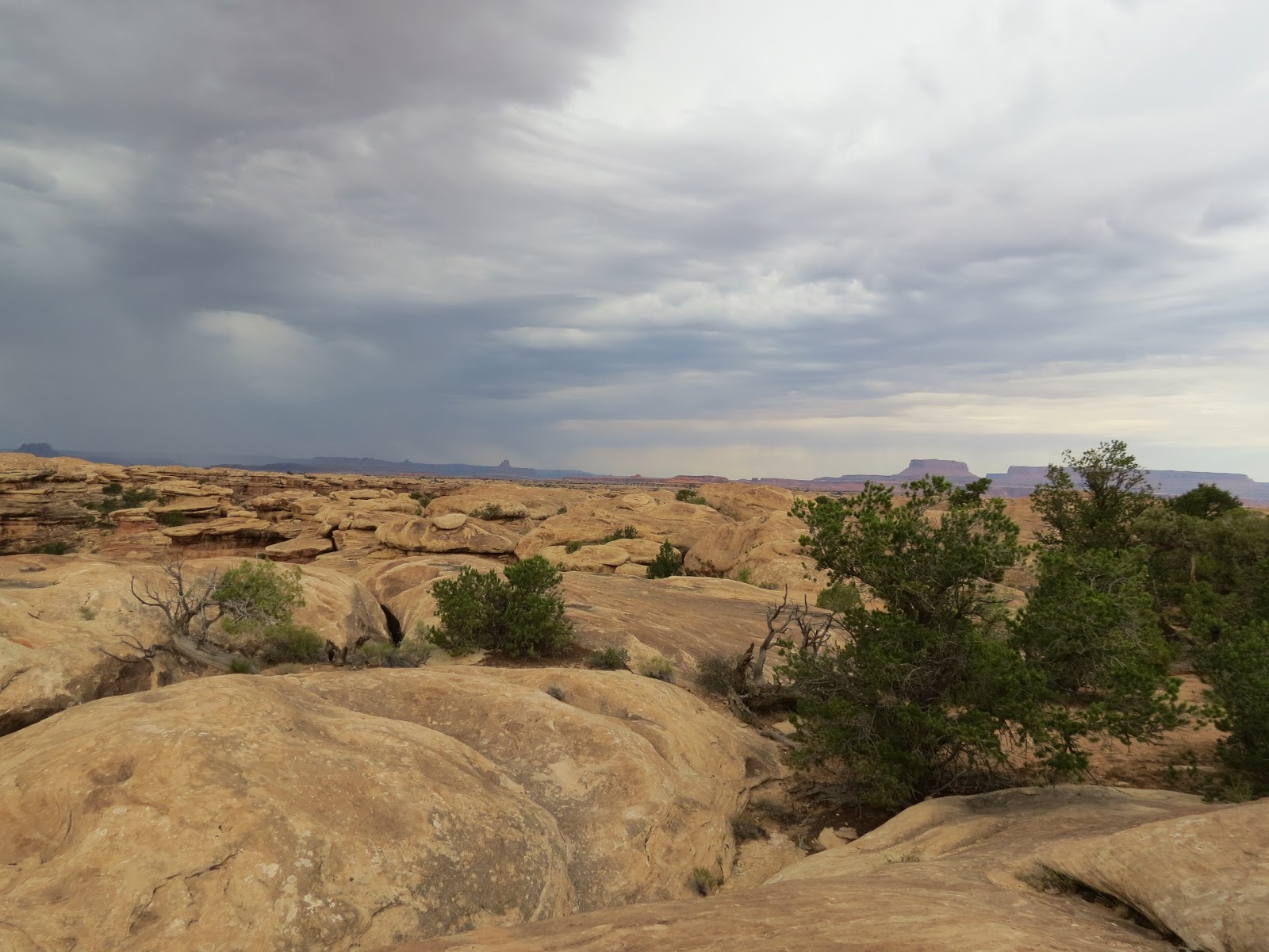
Rough Country

The Weather Is Changing As I Look Out Over This Vast Valley. The Wind Is So Strong I Can Hardly Stand Up And I Certainly Don't Dare Get Near The Edge Of This Over Look. Note The Heavy Rain
Storm Off To The Right And It Formed In A Matter Of A Few Minutes. It Looks Close But Really It Is A Long Way Off.

Big Rain Storm In Distance And I Can Hear A Great Amount Of Thunder. It Is Interesting How The Thunder Reverberates In The Canyons.

Rock Formations On Slick Rock Foot Trail As I Head Back To The Car Which Is Only A Short Distance Away From This Point. You Might Wonder How You Know Where The Trail Is Out In A Place Like This. There Are Little Piles Of Rock Every So Often That Let You Know Where The Trail Is. I Don't See Any In This Photograph But They Are There. I Am Back In The Car And No Rain So On To The Next Stop.

Confluence Overlook Trail. For This One I Just Looked And Did Not Take This Trail Which
Would Have Been Really Tough And Not For Me

This Is A Photograph Of The Confluence Of The Colorado And Green River. You Can See The Two Different Colors Of The Water But It Is About 5.5 Miles One Way From Where I Am Reading This
Sign At Big Spring Canyon Overlook.

You Can See The Start Of The Foot Trail That Would Eventually Lead You To The Overlook
At The Confluence Of The Colorado And Green River 5.5 Miles Away One Way. There Is A
Road For 4 Wheel Vehicle To Get To Within About A Mile Of The Overlook.

View Of The Canyon Rims Around The Big Spring Canyon Overlook

View Of The Canyon Rims Around The Big Spring Canyon Overlook

Interesting Mountains. Look At The Two Layers Of Dark Material. Beautiful Needles.

Rugged Mountains

Closer View Of Mountains
Today the average elevation of Canyonlands is over 5,000 feet. Canyonlands is part of a region called the " Colorado Plateau " an area that stands high above the surrounding country Many years of movement of the earth's crust began to alter the landscape resulting in the Rocky Mountains, Nevada's Basin and Range and the Colorado Plateau. Volcanic activity brought melted rock to the surface and in some place it cooled before reaching the surface creating pockets of harder rock within the surrounding sedimentary layers. Erosion exposed these harder rock creating isolated mountains and hills. Today's landscape is one of erosion. The Colorado and Green River running through the area carved into the geological layer cake, exposing buried sediments and creating the canyons in Canyonlands. Rivers are not the only force at work in the erosion activity. Summer storms bring heavy rains that scour the landscape. Some layers erode more easily than others. As softer rock dissolves away, layers of harder rock form exposed shelves, giving the canyon walls their stair-step appearance. Occasionally, a slab of harder rock will protect a weaker layer under it, creating balanced rocks and towers. Water also seeps into cracks, eroding and widening them until only thin spires remain. Wind blowing sand and dirt also contribute to the erosion process. Interesting enough this process continues today and views I enjoyed today some years in the future may be altered over and over. As I see this wondrous area and think about this - I am awed by the awesome power of God who orchestrates and controls this whole process and to think that I have the honor of worshiping this God and knowing that he loves and cares about me.
I stopped at the ranger station going into and leaving the park to get fresh water and took pictures of the visitor center and the surrounding area but somehow I have managed to erase them. I do this occasionally and I have not figured out how I do it. I told ranger about the people I observed putting landscape materials into their car and she thanked me for being interested and telling her but there is not anything they can do. I also asked her about the rain storm I saw and she indicated for some reason most of the rain goes around the park rather than over it. They will get an occasional shower for example enough to fill the potholes. In fact she said they had not had any flooding in the park since last summer at which time several roads were washed out and have not been repaired yet because of shortage of funds and equipment. Some of the wash outs were 6 feet or more deep. These roads were for 4 wheel travel only and did not impact park visitors other than those that wanted to camp out in certain areas. She said such storms are rare but bad when they do come over the park.
After I got back on Highway 191 and headed toward Moab I had planned to take another side road seven miles up the road that would take me out to The Needles Overlook. This would have been a 42 mile round trip side trip. The ranger I had talked to told me that knowing what I had already seen the trip would not be worth the effort so I continued to Moab. On the way to Moab I saw the following.

Wilson Arch South Of Moab, Utah

Wilson Arch. If You Look Closely You Can See People Walking Up To The Arch And One Person Standing Under The Arch. This arch is behind a road stop store.

Best Western Plus Canyonlands Inn In Moab, Utah
As you can see from the sky it was standing to get late when I arrived at my motel. I found a nearby place to eat then got out a quick travel update and went to bed. Tomorrow will be a busy day as I plan to go to the Arches National Park the entrance which is only a few miles from my motel. So until we meet again here at the blog remember that God Loves you and so do I.
Grandpa Bill
No comments:
Post a Comment