Today is August 22, 2013 and I am having my favorite breakfast the fresh fruit bowl they serve here
at the Best Western East Zion Thunderbird Lodge in Mount Carmel, Utah. Again I had my favorite
booth so I could watch the hummingbirds eat. The restaurant opened several minutes earlier today than usual for which I was thankful because I have so much driving to do today. After filling Lady Blue up with gas at the motel's gas station I hit the road for the Vermillion Cliffs National Monument and the North Rim Of The Grand Canyon National Park. I take highway 89 back down to Kanab. I drive to Vermillion Cliffs. Actually you drive by them and not to them. Following that I went to the North Rim of the Grand Canyon and it is grand. Some of the road leading into the park has some of the most beautiful scenery I have ever seen. Not nearly as crowded as the south rim and in my opinion a whole lot more beautiful. Information at the park indicated there are 10 visitors to the south rim for every 1 visitor to the north rim. You see the Colorado River many more time and much clearer plus you see some features that you don't even know exist from the south rim. But first lets take a look at The Vermillion Cliffs.

Sun Rise On Highway 89 Headed Southeast

Sun Rise On Highway 89 Headed Southeast

Sun Rise On Highway 89 Headed Southeast

Sun Rise On Highway 89 Headed Southeast

View Of Country Side On Highway 89 Headed Southeast. You Can See The Highway Off In
The Distance In The Middle Of This Photograph

View Along Highway 89 Headed Southeast

The Landscape Is Changing.

Kaibab Mule Deer

She Stood And Watched Me Until The Little Ones Were Safe Into The Woods Then She Turned
And Followed Them. I Was Not Able To Stop Soon Enough And Get The Camera To Catch
The Little Ones.
The Little Ones.

This Picture Is Just One Minute Later Down The Road And I See This Flock Of Wild Turkeys. They Are Heading Toward The Road.

I Had To Stop So The Wild Turkeys Could Cross The Road. Interesting That Just Up The Road Is A Mother Fox With Three Little Ones And She Took Them Into The Woods On The Same Side Of The Road That These Turkeys Were Feeding. I Wonder Did I Disturb The Foxes Turkey Dinner. As I Drove Around The Park I Saw Several Other Large Flocks Of Wild Turkeys.

Home On The Range

Yes, I Am Back In Arizona

Bison Along The Road. I Love It They Would Not Stay Where He Put Them

Vermillion Cliffs

Interesting Rock Formation In Canyon Along Vermillion Cliffs

Vermillion Cliffs Off In The Distance


Vermillion Cliffs Off In The Distance


Large Bolder. Look Like Anybody You Know. At Jacob Lake I Turn To The Right Onto Highway 67 Which Ends At Bright Angel Point Inside The North Rim Of Grand Canyon National Park. At This Point Where You Leave The Main Highway There Are Several Motels, Restaurants And
Other Shops And They Were All Doing A Booming Business
Other Shops And They Were All Doing A Booming Business

Beautiful Meadows On Both Sides Of The Road For Several Miles That Back Up To Forest Of
Ponderosa Pine With A Few White Birch

Meadow On The Other Side Of The Road

More Beautiful Meadow. At Various Times You See All Kind Of Animals Grazing In These Meadows. After A Few Miles Of A View Like This I Turn Off On A Dead End Road That Goes To Point Imperial, Vista, Encantadora, Angels Window, And Cape Royal.. From These Meadows Which Are Roughly 4,000 Feet In Elevation This Road Climbs And Winds Up Often Very Step Grades Through Beautiful Tall Forest To Point Imperial.

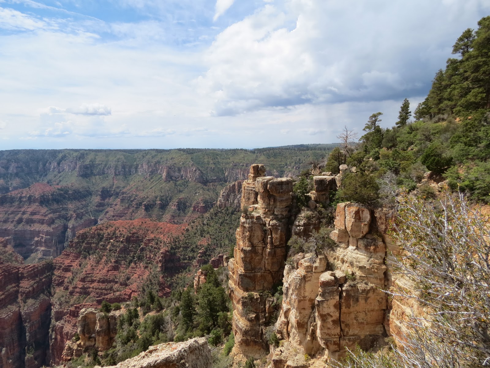
Point Imperial Elevation 8803 Feet Which Is The Highest Elevation In The Park. All Of The View
Points Along This 20 Mile Stretch Of Road Are Breath Taking. From This Point When You Look
Toward The Eastern End Of The Grand Canyon And The Painted Desert Far In The Distance.
Toward The Eastern End Of The Grand Canyon And The Painted Desert Far In The Distance.

Information About The Canyon From This View Point

Enlargement Of Information Sign
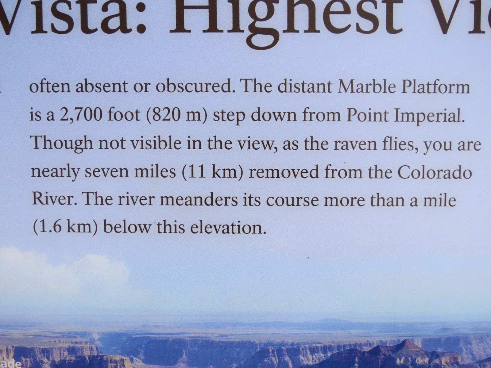
Enlargement Of Information Sign

Enlargement Of Information Sign

Enlargement Of Information Sign. The Height And Depth Of It All
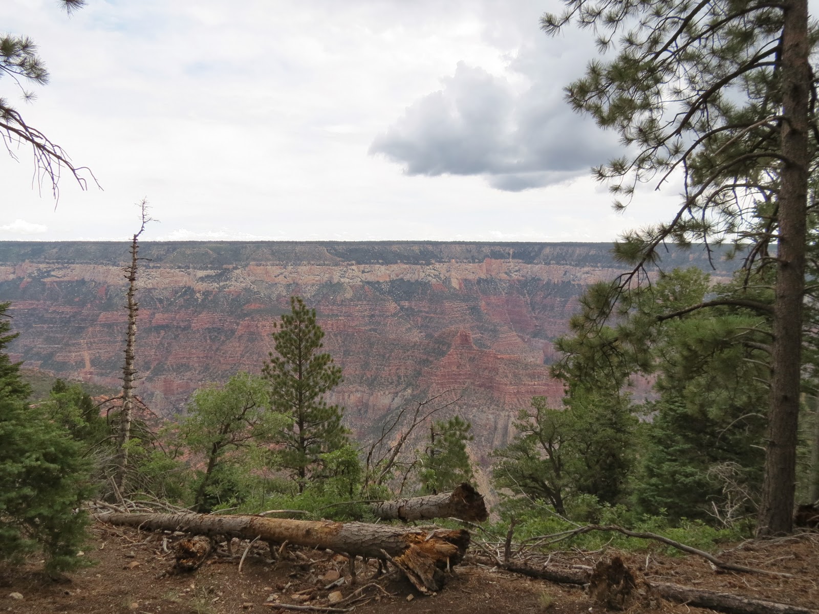
Looking Over The Edge Of North Rim Of Grand Canyon

Looking Into Grand Canyon

Looking Into Grand Canyon

Looking Into Grand Canyon

Looking Into Grand Canyon. Note The Jet Streams High In he Sky.

Looking Into Grand Canyon. Standing All Alone.

Looking Into Grand Canyon

Looking Into Grand Canyon. As You Drive Along The Rim Of The Canyon You Have Pull Out Parking Places Where You Can Stop And There Are Many Of Them Each With An Entirely Different View.

Information Sign

Looking Into Grand Canyon

Looking Across Grand Canyon To Vermilion Cliffs. They Would Be Several Miles Away

Looking Into Grand Canyon

Trees Missing Due To Forest Fire In The Past

New Trees Starting To Fill In Spaces Vacated Due To Fire

Typical View When Driving Through Forest On North Rim

White Birch Trees Mixed In With Ponderosa Pines. The Trunks Of These Birch Are Very Large And
The Birch Are Very Tall As They Compete For Sunlight With The Very Large And Tall Ponderosa Pines.
The Birch Are Very Tall As They Compete For Sunlight With The Very Large And Tall Ponderosa Pines.

Lady Blue In Front Of Hugh Ponderosa Pine

North Rim Visitor Center
View Of Canyon From Visitor Center Parking Area

North Rim Visitor Center. The Park Was Crowded Today As Was The Visitor Center. I Bought A
Few Items. Literature At The Park Indicates That 5 Million People A Year Visit The Park.The Canyon
Is 6,000 Feet Deep At Its Deepest Point And 18 Miles Across At The Widest Point. The View From
The North Rim Is Different Than The South Rim Because The North Rim Is Higher In Elevation.
Few Items. Literature At The Park Indicates That 5 Million People A Year Visit The Park.The Canyon
Is 6,000 Feet Deep At Its Deepest Point And 18 Miles Across At The Widest Point. The View From
The North Rim Is Different Than The South Rim Because The North Rim Is Higher In Elevation.

Grand Canyon Lodge. I At Lunch At A Nearby Deli.

Information About Grand Canyon Lodge

Enlargement of Grand Canyon Lodge Information

Lodge Employees In 1930 singing To Departing Guest. Look At Those Cars Or I Guess It Would Be
Better To Call Them Vans Or Buses. This Does Not Happen Now.
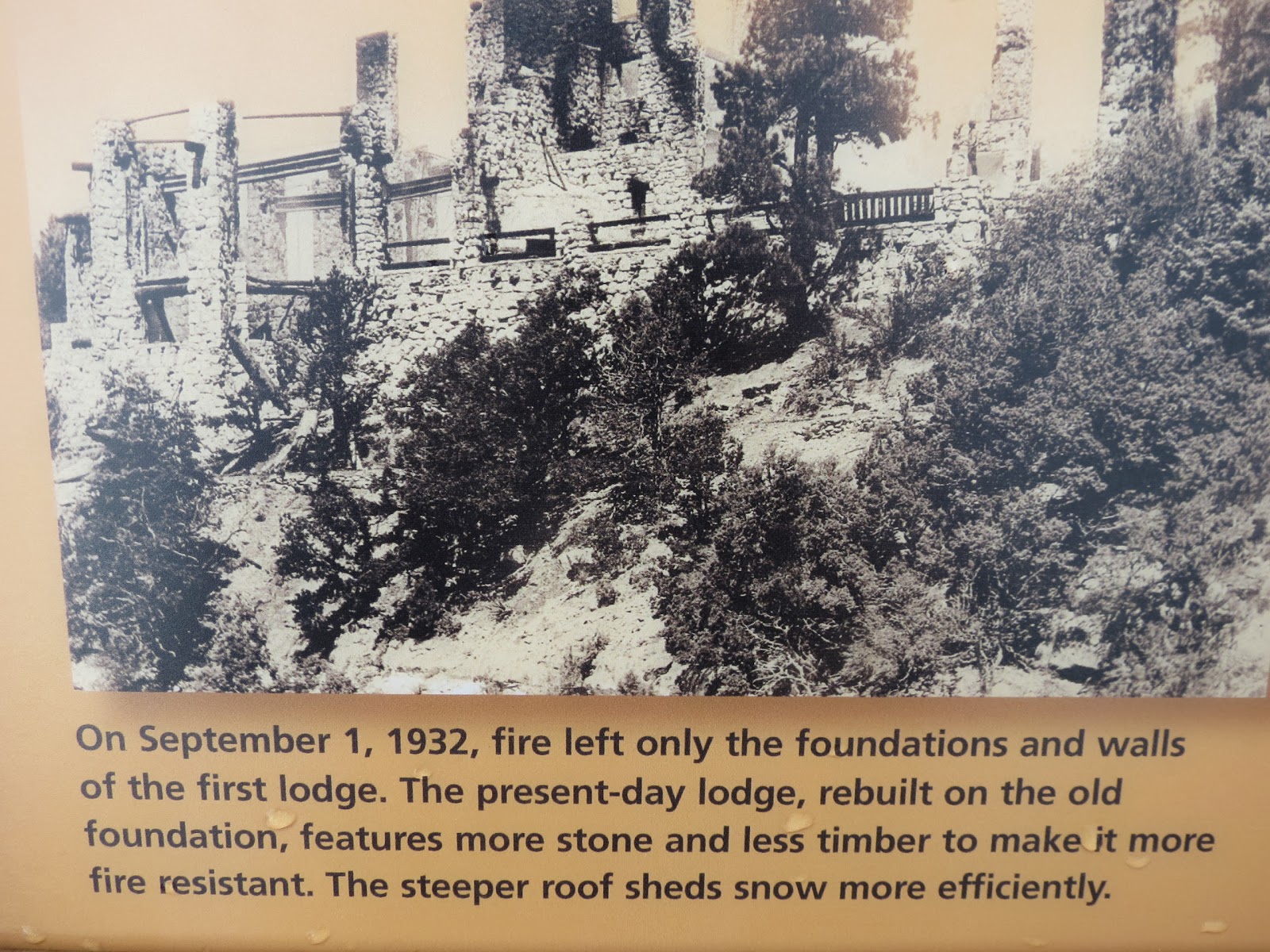
Fire Destroyed The First Lodge

Drawing Of The Original Lodge.

Log Cabin Rental Units

Log Cabin Rental Units

Drink In The View Has A Double Meaning Here

Drink In The View Information Sign

Drink In The View Information Sign

Drink In The View Information Sign. Roaring Springs


This Is The Trail From The Lodge To Bright Angle Point Where You Can Hear Roaring Springs.
I Had To Turn Back Because The Trail Was Getting To Steep And My Legs Would Never Have
Made It. This Was A Major Disappointment For Me As This Was The One Thing I Really Wanted
To See. The Roaring Spring Is 3,000 Feet Below You At The Trail End. This Is The Water Source
For Both The North Rim And The South Rim
For Both The North Rim And The South Rim

View Into Canyon On Roaring Springs Trail

View Into The Canyon

View Into The Canyon

View Into The Canyon. What A Great View. I Love The Contrast Of The Green Of The Pines With
The Browns Of The Canyon
The Browns Of The Canyon

View Into The Canyon. If You Will Notice The Point To The Top Left Of The Photo Is An Example Of What I Mentioned Earlier That At Each One Of These Points There Is A Place To Park And Take In
The View. I Noticed In The Literature That It Advised That If You Stop At Each Of These Stopping Point And Take The Short Trail Out To The Overlook That This Would Take Half A Day. I Can Attest To The Accuracy Of That.

View Into The Canyon. Look At The Sharp Ridge On The Cliff To The Right. It Is A Long Way Down There About A Mile.

View Into The Canyon. Sorry About The Foggy Haze In The Area Today. I Am At The Next View Point From The Last Photo. The Sharp Ridge To The Left Is The One I Pointed Out To You At The Last stop.


Large Rock Formation
 Photograph From Bright Angle Trail. Note That I Am Far Enough Down The Trail That I Am Just About Level With The South Rim

 Enlargement Of Living Delta To Rim


Photograph From The Bright Angle Point Trail
 Photograph From The Bright Angle Trail
 Grand Canyon Lodge As I Come Back Up The Bright Angle Trail
 This Is Such A Large Place It is Just Awesome. The Colorado River Runs In The Deepest Canyon.
 The Haze Has Moved In Again. On The Left It Looks Like Water Has Been Running Down Through
That Area But These Places Are Actually Rock Slides.
 Here You Can See A Trail That Comes Down From The South Rim To The Floor Of The Canyon.
Notice On The Right The Trail Seems To Just Go Over The Cliff
 I Completely Agree With His Comments. " Leave It As It Is. " The Park Became A National Monument On January 11, 1908 And Was Designated A National Park On February 26, 1919. The North Rim Was A Popular Place For Hunters. One Notably Hunter Was Former President Teddy Roosevelt Who Eventually Declared The Area A Game Preserve And In 1919 Persuaded Congress To Protect The Area By
Declaring It A National Park. Perhaps We Would Not Be Enjoying The Park If It Had Not Become A National Park Because There Was A Proposal To Dam The Colorado River Making The Canyons A
Very Large Lake. One Interesting Bit Of Information Is That One Reason The North Rim Area Was Not Developed Earlier Was Because Its Ownership Was In Question. Both Utah And Arizona Claimed The Territory. When Arizona Was Granted Statehood In 1912 The Issue Was Finally Settled.
 Big Step Down. You Can Say That Again.
 View Of The Fault Line.
 Explanation Of The Fault Line.
 Canyon Wall Where You Can See Where Rock Slides Have Occurred.
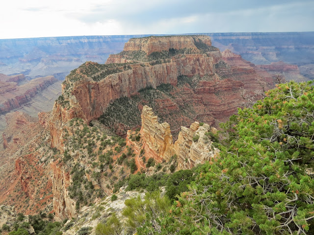
 Looking Into The Canyon From Roosevelt Point
 Looking Into The Canyon From Roosevelt Point
 Trail Coming Down Into The Canyon
 Looking Into And Across The Canyon. The Canyon Is Not Just One Canyon But Several Side Canyons That Lead To The Main Canyon
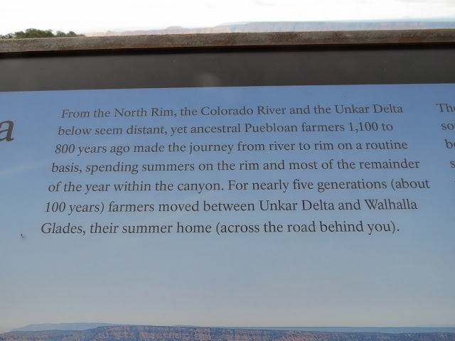
 Prehistoric Life On The Walhalla Plateau.


 Living Delta To Rim
 Enlargement Of Living Delta To Rim


That Area But These Places Are Actually Rock Slides.

Notice On The Right The Trail Seems To Just Go Over The Cliff

Declaring It A National Park. Perhaps We Would Not Be Enjoying The Park If It Had Not Become A National Park Because There Was A Proposal To Dam The Colorado River Making The Canyons A
Very Large Lake. One Interesting Bit Of Information Is That One Reason The North Rim Area Was Not Developed Earlier Was Because Its Ownership Was In Question. Both Utah And Arizona Claimed The Territory. When Arizona Was Granted Statehood In 1912 The Issue Was Finally Settled.


This Life Style Seemed To Be The Same Throughout All The Areas I Have Visited. On My Last Visit To The South Rim I Had Some Photographs Of Caves Possibly Used By The Indians. The Interesting Thing About It The Stories Told About What The Caves Were And What They Were Used For Were Entirely Different Than This. I Tend To Believe This Is The Real Story. It Is Consistent With What I Have Found Through Out The Area. Often Times Stories Told By Guides And Tour Pilots Are Just That " Stories That Sound Good " For The Tourist But In Fact Do Not Tell The True History Of The Canyon And Its Early Inhabitants. Excavation In The Canyon Floor Have Found Numerous Caves And Structures They Built To Stored Their Grain.

Delta Area Where Indians Lived Part Of The Year

Large Rock Formation In The Canyon

Colorado River.


The Grand Canyon


Prehistoric Life On Walhalla Plateau
 Enlargement Of Living Delta To Rim
 Discovering The Past
 Archaeologists Excavating Ruins At Unkar Delta
 Hundreds Of Pine Cones Under Ponderosa Pine Tree
 Sign Pointing To Cape Royal. It Is Roughly 26 Miles One Way From The Grand Canyon Lodge Area
To This Point Then There Is A Long Trail That Is Fairly Flat That Goes Out To Several Viewing Points
And Goes Through Widely Different Plant And Tree Life Than In Other Parts Of The Park.
 Sign Telling About Plant Life
 Big Sage Brush And Its Uses
 Big Sage Brush
 Cliffrose
 Cliffrose
 Cliffrose
 Angels Window
 Looking At The Colorado River Through The Angels Window. From The South Rim You Don't Even Know This Exists.
 View Of The Rock Ridge In Which The Angles Window Is Located. Note The Overlook View Point
On Top The View From That Point Is Unbelievable.
 View Of Canyon From Atop Of Angles Window
 View Of Canyon From Atop Of Angles Window. Marvelous View.

Looking Into Side Canyon Near Angles Window


To This Point Then There Is A Long Trail That Is Fairly Flat That Goes Out To Several Viewing Points
And Goes Through Widely Different Plant And Tree Life Than In Other Parts Of The Park.


On Top The View From That Point Is Unbelievable.


Looking Into Side Canyon Near Angles Window

View Of Canyon Near Angles Window
 Pinyon Nuts
 Pinyon Pine Trees
 Utah Juniper
 Utah Juniper
 Sapsucker Woodpecker At Work On A Juniper Tree
 Advise On What To Do When Lightening Is In The Area.
 Another View Of The Colorado River. The Unkar Flat Is In The River Bend To The Right. I Think The
Unkar Creek Is Visible To The Right Of The Big Rock Formation Beside The Unkar Flats.
 Canyon View And Colorado River
 Canyon View. Note The Bare Dirt Beyond The Big Rocks. That Is Caused By People Standing There Trying To Get A Better View. Very Dangerous.
 Marvelous Rock Formation. Isn't It Amazing That The Trees Are Growing All Over These Formations
 The Views Of The Canyon And The Colorado River Are Spectacular From The North Rim
 View Of Canyon


 I Pulled Off The Road And Just Watched These Buffalo For A Few Minutes


Unkar Creek Is Visible To The Right Of The Big Rock Formation Beside The Unkar Flats.


View Of Canyon. Just As I Took The Photograph Above My Camera Flashed On A Warning That My Battery Was Depleted. So I Turned It Off And Headed Out Of The Park. I Wrote In My Notes That " Camera Battery Is Out So Head Back To Motel. I Am Finished Anyway " Which Was Accurate As I
Was Ready To Leave As I Had Seen All The View Points And Taking The Trails I Could Take But
Not All The Trails I Wanted To Take. Actually I Guess My Real Feeling Was That I Wished I Had A
Lawn Chair And The Time To Just Sit For Hours Looking At The View And Seeing Something New
Every Second. The Steep Winding Road Through The Forrest As You Come Down Into The Valley
Is Beautiful.

When I Got Down To The Area Where The Large Meadows Are On Both Sides Of The Road I
Couldn't Believe My Eyes Because There Was This Large Herd Of Buffalo Grazing In The Meadow.
I Stopped And Turned The Camera On Because I Have Learned That After Turning It Off For A While
You Can Usually Get A Couple Of More Shots And The One Above And Following Are Those Shots.

So now I start the long beautiful drive back to the motel. As I went by the Vermillion Cliffs I stopped at a couple of pull off points to take a few more picture but the battery was truly depleted and no amount of rest was going to work so you will never see what I saw. So sorry. I got back to the motel at 7:32 local time. I washed up and went to partake of the excellent salad bar here. Tomorrow is another busy day as I head for Zion National Park and really head west at that time. I have enjoyed my stay at this motel.
Remember God loves you and so do I.
Today's Comment:
" They that sow in tears shall reap in joy. " Psalm 126:5.
Grandpa Bill
One of the highlights of the Grand Canyon North Rim is Bright Angel Point, which lies at the end of the Bright Angel Point Trail, a half-mile loop (800 m) and one the most popular of the North Rim corridor trails. From the point, you can see and hear the rush of Roaring Spring, the North Rim's only water source, which lies 3,600 feet (1,100 m) below the rim. You'll find more scenic overlooks at Cape Royal, one of the most spectacular settings in the Grand Canyon.
ReplyDeletegrand canyon south rim air and ground tour